

If you’ve only got one day in the Yorkshire Dales and you’re feeling strong, the Etape du Dales route is the one for you. The famous Etape du Dales sportive takes place each year, organised by the Dave Rayner Fund, and completing it puts you in an exclusive band of cyclists that are more mountain goat than normal human being. Of course, ideally you’ll ride it as part of the official event, but if you can’t make the set date or prefer solitude, do it anyway. There are good bragging rights at stake (!)…
…but more importantly, you won’t forget this ride. It’s up there with the best of the best.
The route takes in Fountains Fell, Stoops Moss, Garsdale Head, Lamps Moss, Tan Hill, Turf Moor, Buttertubs Pass and Fleet Moss. These are some of the hardest climbs in the UK – and the scenery you’ll ride through is mind boggling: windswept, barren, glorious and seemingly endless. If you ride alone, you may wonder if you’re the last person left on the planet.
This is one of the hardest sportive routes out there and a huge day in the saddle, whoever you are.
Note: this guide and our GPX is based on the 2019 route. The route is subject to change in future editions of the event. Looking for the Etape du Tour? Read this.

Clare Dewey is a cyclist with a passion for travel. She set up epicroadrides.com in 2018 to help make it easy for cyclists to explore the world by bike. Today her mission is still inspiring cyclists to discover new places on two wheels - and doing what she can to make sure they have the best possible time while they're there. Clare has visited 50+ destinations around the world, many of them by bike.
Want to connect with Clare? Find her over on LinkedIn.

We have one overriding rule at Epic Road Rides: would we suggest this to our friends? This means we don’t work with every brand that wants to work with us. We may not have personally used or been on a trip with every brand we collaborate with, but after many years in the industry, our team knows a lot of people, and we only say yes to the brands we would be happy to use ourselves or that we’d share with a friend.
Highlights
The Etape du Dales route takes in most of the best known climbs of the Dales and delivers up almost uniformly jaw-dropping scenery, so choosing a highlight is tricky.
The big, well-known climbs deliver in spades of course, but perhaps unexpectedly one thing we really loved about this ride was getting onto some roads that aren’t often in the limelight. The scenery at the top of Lamps Moss was really special – mile after mile of remote, barren moors with not a soul around, no cars, no bicycles, no electricity pylons. We felt totally alone and it was wonderful.
 Lower reaches of Garsdale Head
 Wild, remote moorland around Lamps Moss
 Etap du Dales copyright Epic Road Rides-4") Summit of Tan Hill
Summit of Tan HillEtape du Dales ride log
1. Threshfield to Stainforth (via Fountains Fell): 0 to 31 km
You turn right on the B6160 (signed Kettlewell 6) and you’re heading north at the with a huge day ahead of you. While this first section between Threshfield and Nateby is most definitely very rural, compared with the deepest darkest Dales to come, it’s much more “in civilisation”. Now you feel like you’re in attractive well tended countryside, later on you feel like you may just be the last person left on the planet!
You following the River Wharf until Kilnsey when you turn off left under the craggy peaks of Hawkswick Clowder. Spot the climbers clinging to the rock face!
Gradients are mildly undulating at this stage – take it easy and enjoy the wide views over the valley bottom. Continue on through pretty Littondale past the villages of Arncliffe and Litton, until you take a left, climbing up from Halton Gill through moorland.
This left turn after Halton Gill marks the start of the Fountains Fell/Dale Head climb. There’s a 16% sign to warn you of what’s to come, as you grind up with Fountains Fell itself on your left, famous for its boggy summit. On the right is the dramatic Pen-y-Ghent. Once at the top, you undulate along the summit for about four kilometres, before passing through a gate by a farm building (it was shut on one of the occasions we came through, which was a bit odd).
 Quiet road heading towards Arncliffe, Littondale
 Climb up from Halton Gill
 Nearing the top of the Fountains Fell climb, with view to Pen-y-ghent
2. Stainforth to Nateby (via Stoops Moss and Garsdale Head): 31 to 82 km
From Stainforth, you turn onto the B6479, one of the more major roads you’ll ride on this route, and stay on it for around 15 kilometres, to the impressive Ribblehead Viaduct. Overall you’re climbing through this section, but it feels lumpy.
In front of the Ribblehead Viaduct you turn right on the B6255 and the next 7 kilometres sees you climb Stoops Moss: 6 kilometres at a 3% average gradient and 6% maximum gradient. It’s all stone walls, green fields with sheep and stone farm buildings. The summit comes just after you turn off the B6255 (signposted Dent and Dentdale) onto a narrow country road that heads up into the moor.
There’s then a fast, plunging descent down into Dentdale, under a dramatic viaduct, before climbing up the brutal slopes of Garsdale Head. There are a few gruelling hairpins through wood at the bottom of the climb, before the road straightens out as you pass Dent train station (which is the highest mainline station in England). It’s then a lung busting, straight climb up through moorland, until the road flattens near some trees at the top. Ridewithgps gives an average gradient of 10%, but it feels much harder than that!
It’s a very steep, fast descent to Garsdale train station with fantastic views over Baugh Fell and Swarth Fell. The roads undulate between here and Aisgill before descending as you head almost due north to Nateby along Mallerstang Common under Wild Boar Fell. You pass two spectacular viaducts, as well as the usual array of farms surrounded by green fields, sheep and dry stone walls.
 Passing the spectacular Ribblehead Viaduct
 The gruelling climb up Garsdale Head
 The more benign road heading north towards Nateby
3. Nateby to Keld (via Lamps Moss): 82 to 95 km
Nateby is a tiny hamlet that you’re through before you’ve realised you’ve arrived. You turn right and almost immediately are climbing, over a cattle grid, and onto endless, sheep strewn moorland, past stone walls and barns. It’s around 4km to the top of the Lamps Moss climb, and while the 17% sign you pass will make your heart sink, this is really only relevant for the last stretch before the top. Our GPS data shows an average that’s closer to 8% for the whole climb – though, as ever, it might feel harder if you get a headwind.
From the top, there’s then a wonderful rolling 5km or so of blissfully empty moorland, before a descent down to the River Swale and the hamlet of Keld.
 On the way up Lamps Moss
 The road stretching away up Lamps Moss
 Descent to Keld
4. Keld to LangThwaite (via Tan Hill): 95 to 114 km
Enjoy the descent since after you cross the bridge, you’re soon climbing again – you pass a sign for Tan Hill 4 miles (6.5km) and an unwelcome 25% warning. The average gradient for the Tan Hill climb sits around 4%, but it’ll feel harder than that, especially if it’s windy. We rode it on a bleak grey day, and it truly felt like we were alone in the world. It’s desolate, windswept and exposed – you wouldn’t want to be up here in bad weather. As you reach the top, you’ll suddenly spot the happy sight of the chimneys of the Tan Hill Inn, the highest pub in Britain. When we were there in May, there were snow ploughs parked up next to the pub, a sign of how cold it gets up here.
There are superb views from the top of Tan Hill and also as you descend down from the moor for around 12 kilometres into the green valley of the Arkle Beck. Just before Langthwaite you turn right, it’s signposted for “Low Row 3” and is quite hidden, so don’t miss the turn.
 Etap du Dales copyright Epic Road Rides") Crazy steep gradients near the bottom of the Tan Hill climb
Crazy steep gradients near the bottom of the Tan Hill climb  Etap du Dales copyright Epic Road Rides-3") Climbing Tan Hill through windswept moorland
Climbing Tan Hill through windswept moorland Etap du Dales copyright Epic Road Rides-5") The summit of Tan Hill and the Tan Hill Inn
The summit of Tan Hill and the Tan Hill Inn5. Langthwaite to Thwaite (via Turf Moor): 114 to 130 km
From here you climb the 1.5km up Turf Moor. It’s short but sharp, with average gradients around 8%. As well as the usual cattle grid out onto the moor, you pass by the less usual sight of what looks like grassed over quarry tippings. On the descent down the other side, watch out for a couple of hairpins and a cattle grid, before you reach a ford. Take the footbridge rather than trying to cross the ford – unless you fancy a bath! Those that trust to luck and stay mounted will have a better chance of getting up the vicious slope the other side of the ford, though they could also end up in hospital… From here you head down to the village of Low Row, but more care is needed – the road down is seriously steep.
Low Row is a pretty place with the ubiquitous stone houses and views across to the hills behind. The next eight kilometres along Swaledale are picture-postcard pretty, past terraced fields and barns in the green valley bottom. They’re also relatively flat; enjoy the respite.
Just before Muker, the road starts to rise but the real climb up Buttertubs doesn’t begin until you reach the junction signposting Thwaite a few hundred metres away.
 Etap du Dales copyright Epic Road Rides-6") Steep descent from Tan Hill towards Langthwaite
Steep descent from Tan Hill towards Langthwaite Looking down to the cattle grid and ford on the way down Turf Moor towards Low Row
 Another steep descent into Low Row
6. Thwaite to Threshfield (via Buttertubs Pass and Fleet Moss): 130 to 176 km
From the turn, it’s just under 3km to the first peak, there’s a short descent and then a final steep climb up to the summit. Get all the details on the Buttertubs climb, here. Enjoy the 6km rolling descent the other side into Hawes.
 Etap du Dales copyright Epic Road Rides-2") Looking up the Buttertubs Pass from towards the bottom on the Thwaite side
Looking up the Buttertubs Pass from towards the bottom on the Thwaite side Etap du Dales copyright Epic Road Rides-4") View from the Buttertubs Pass
View from the Buttertubs Pass Etap du Dales copyright Epic Road Rides-8") Nearing the summit of the Buttertubs Pass
Nearing the summit of the Buttertubs PassWith nearly 90 miles in your legs, the final climb of the day is really going to hurt – especially when it’s Fleet Moss! It starts just outside Hawes. Get our full guide to this epic climb, here.
 Etap du Dales copyright Epic Road Rides") Looking up the road to the daunting Fleet Moss
Looking up the road to the daunting Fleet Moss  Etap du Dales copyright Epic Road Rides-4") On the way up the top of the steep side of Fleet Moss
On the way up the top of the steep side of Fleet Moss Etap du Dales copyright Epic Road Rides-6") And again!
And again!From this point, the good news is that it’s pretty much downhill all the way home. You ride through Oughtershaw and into Langstrothdale, where you cycle along beside the River Wharfe, passing through various tiny hamlets in the valley bottom.
You get to the larger village of Buckden and are now in Wharfdale, passing stone wall enclosed fields, cows and sheep contentedly grazing and various little villages. You ride through Wharfdale, via Kettlewell, all the way back to Threshfield, where you began the ride.
Time to eat and put your legs up!
Café stops
This is a very long, very hard route. If you’re tackling it as part of the sportive then of course you’ll have the benefit of feeding stations on the way. If not, you’re likely to need to stop and top up with food and drink en route. Many sections of the route are very remote and you can’t assume every hamlet/village on the map will have a shop or cafe. Here are some suggestions for places to stop:
Threshfield and Grassington (0 and 176 km) – plenty of shops and cafés. There’s also a garage after Threshfield.
Horton in Ribblesdale (37 km) – Golden Lion Hotel, The Crown Inn, tea rooms
Garsdale Head (66km) – The Moorcock Inn
Low Row (120 km) – Punchbowl Inn and tea rooms
Gunnerside (123 km) – Kings Head
Hawes (140 km) – plenty of shops and cafés
Accommodation
If you want to do this route from Threshfield, it’s best to stay here or Grassington. Otherwise, assuming you’re not doing it as part of the sportive, you could stay anywhere on the route and start/finish there.
For more detailed thoughts on the best places to stay in the Dales for cyclists, read our Yorkshire Dales cycling guide.
Tips
Which way should you ride the Etape du Dales route?
Note that until 2018, the Etape du Dales route went in an anti-clockwise destination. This was reversed in 2018 so in 2018 and 2019 the route went clockwise.
We contacted the organisers and asked what the plan was for 2020. Apparently they’ve surveyed the riders that took part in 2019 and it looks like it will stay in the clockwise direction. We asked which direction was harder and were told “There is a difference of opinion between the riders. The fitter, faster rides think the old direction is harder as although the climbs aren’t as steep, the roads in between are more wearing. The current direction has some really difficult climbs but long gradual descents, complemented by favourable tailwinds which aid speed and recovery. The record time is faster in the current direction. The riders completing the course around the average time or slower say it’s much harders. The climbs are much steeper and the last climb of Fleet Moss is daunting.”
So, if you’re riding this route take your pick on the direction front! Either way you’ll get a workout that your legs won’t forget for a few days (minimum)!
Other tips
Read our tips for cycling in the Yorkshire Dales before you set out.
Start early. The Etape du Dales is likely to take you anywhere between 6 and 10 hours to complete.
This ride can be chopped up in many different ways if you just fancy doing part of it, or breaking it into sections. For example a loop from Thwaite: Keld – Tan Hill – Langthwaite – Low Row – Buttertubs Pass – Thwaite.
Watch out for the cattle grids – they’re everywhere on this ride! Approach them straight on, don’t brake and don’t swerve.
We’ve never seen so many gradient warning signs – 17%, 20%, 25% everywhere! Make sure you bring your climbing legs and are confident descending on narrow, country roads.
There are lots of cars around the Ribblehead Viaduct – take care. Want to know more about the iconic viaduct? This article has more information and some videos too.
 Etap du Dales copyright Epic Road Rides-2") Watch out for sheep on the road
Watch out for sheep on the road Stone farm buildings are dotted all over the Dales
 This ride has SO many steep gradient warning signs!
Want more?
Don’t miss our main guide to the Yorkshire Dales, which has links to all our rides and information on where to stay, when to visit and bike hire. You can find links to more of our route guides in the Articles section below. Happy riding!
Got a question for Clare?
Fill out this form and we will send it to Clare. We aim to get you an answer within 24 hours where possible!Clare Dewey is a cyclist with a passion for travel. She set up epicroadrides.com in 2018 to help make it easy for cyclists to explore the world by bike. Today her mission is still inspiring cyclists to discover new places on two wheels - and doing what she can to make sure they have the best possible time while they're there. Clare has visited 50+ destinations around the world, many of them by bike.
Want to connect with Clare? Find her over on LinkedIn.
First Published: 01 August 2019
All metrics in this article are approximate.
The contents of this website are provided for general information purposes only. It is not intended to amount to advice and you should not rely on it. You should carry out your own due diligence and risk assessments and take professional advice. Views expressed by interviewees or other users of this website do not necessarily represent our views. We make no representations, warranties or guarantees, whether express or implied, that the content on our website is accurate, complete or up to date. If you use any information or content on this website, download from, or otherwise obtain content or services through our website, it is entirely at your own discretion and risk. Epic Road Rides Ltd disclaims all liability and responsibility arising from any reliance placed on the information and content on this website. Find out more here.
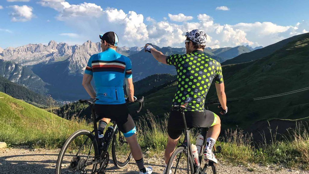
Sponsor Message
Like the kit we're wearing?
We’re proud to be brand ambassadors for Stolen Goat. Their kit is fantastic quality and we love their bold, bright designs. Their customer service is second to none.
Find out how we got to know Stolen Goat and read our candid kit reviews here, or head straight to their site and check them out yourself.
Got a question for Stolen Goat?
Fill out this form and we will pass it to Stolen Goat who aim to reply (within 24 hours wherever they can!)
Comments