


Cycling the Carretera Austral in Chile is the ultimate option for cyclists craving remote roads, wide horizons and a true sense of adventure!
This legendary long-distance route stretches for over 1,200 kilometres. It heads deep into Patagonia, home to some of South America’s wildest and most remote landscapes. You can expect towering Andean peaks, wild turquoise rivers, dense forests, hanging glaciers and long stretches of gravel.
It is a tough route that demands resilience, but the rewards are well worth it.
In this article, we hear from Claudia Huepe at Cicloaustral. Cicloaustral have organised bike tours along the Carretera Austral since 2013. Claudia shares expert tips for cycling in Patagonia, plus their highlights of the Carretera Austral route. We love Claudia’s passion and knowledge of this route; she has ridden the Carretera Austral 10 times and supported bike tours along the route more than 50 times.
Does this sound like your kind of adventure? Read on!

Claudia Huepe is the co-founder of Cicloaustral Chile and has spent over a decade promoting the Carretera Austral as a global cycling destination. With a degree in ecotourism, she has played a key role in developing cycling experiences that connect riders with Patagonia’s landscapes and communities.
Through her work on guided tours, self-supported trips and the bike rental system, Claudia has focused on making travel both smooth and meaningful. Her goal is to create journeys that are not only memorable and immersive, but also bring lasting, positive impact to this remote and rural region.

We love to introduce our community to cycling businesses, destinations and ideas that we think are genuinely interesting. Cicloaustral caught our attention because of its focus on cycling in Chile, which felt like a natural fit for Epic Road Rides and our readers. We were therefore pleased to work with the Cicloaustral team on this article.
Cicloaustral paid for this advertisement feature. Our decision to collaborate reflects our view that the brand is relevant to our readers; it is not a formal approval, audit or guarantee of its services. Unless we expressly say otherwise, we have not personally taken the trip described or independently verified information supplied by Cicloaustral.
As with any travel purchase, please check the latest trip details, terms and customer protections directly with Cicloaustral before booking. Any booking is made with Cicloaustral, not Epic Road Rides.
Always check current travel information and advice. For visitors from the UK, the UK government travel information pages are here.
Table of contents
There’s a lot of information in this article! So to help make it more digestible, we’ve broken it down into five parts:
- Part 1: Overview
- Part 2: Why it’s a must-do
- Part 3: Carretera Austral bike tours
- Part 4: Practicalities and tips
- Part 5: Why book with Cicloaustral
Sponsor Message
Which Carretera Austral cycling trip is right for you?
Join a guided tour, choose a self-guided trip or hire a bike for your own adventure.
Cicloaustral was founded in 2013 and has organised Carretera Austral bike tours for over 10 years.
They have several guided bike tours along the route, including options in the north and south. You can also ride all 1,200 kilometres on a self-supported bike tour with the help of their services, such as bike hire and app navigation.
Here are their most popular itineraries!
Got a question for Claudia from Cicloaustral?
Fill out this form and we will pass it to Cicloaustral who aim to reply (within 24 hours wherever they can!)
The Carretera Austral at a glance:
| Northern Carretera Austral | Southern Carretera Austral | |
| Start | Puerto Montt or Puerto Varas | Coyhaique |
| Finish | Coyhaique | Villa O’Higgins |
| Riding | Mainly asphalt, with gravel sections and challenging climbs | Predominantly gravel, with longer gaps between towns and services |
| Guided Tour | View Cicloaustral’s northern tour | View Cicloaustral’s southern tour |
Part 1: Overview of the Carretera Austral
The Carretera Austral is officially known as Route 7. It continues from the Pan-American Highway (Route 5) into Chile’s remote southern regions.
This magnificent route spans over 1,200 kilometres (746 miles) from Puerto Montt to Villa O’Higgins in southern Chile, South America.
During the journey, the route passes through two major regions; it starts in the Llanquihue Province of the Los Lagos Region and continues through the entire Aysén Region. There are many highlights along the way, from National Parks, including Patagonia National Park, to General Carrera Lake. Find out more below.
Are there different options for riding the Carretera Austral?
The Carretera Austral is commonly divided into two sections:
Northern Carretera Austral: this runs from Puerto Montt or Puerto Varas to Coyhaique.
The northern section offers multiple ways to reach Chaitén, either by taking the bimodal ferry system from Hornopirén to Caleta Gonzalo, following the Estuario de Reloncaví route, or boarding a direct ferry from Puerto Montt to Chaitén.
From there, the road continues south through dense forests, fjords, and rivers, gradually transitioning into the more expansive valleys of Aysén until it reaches Coyhaique. This section has a mix of gravel and paved roads, making it slightly more accessible.
If you want support for riding the Northern Carretera Austral, here’s our Northern Tour.
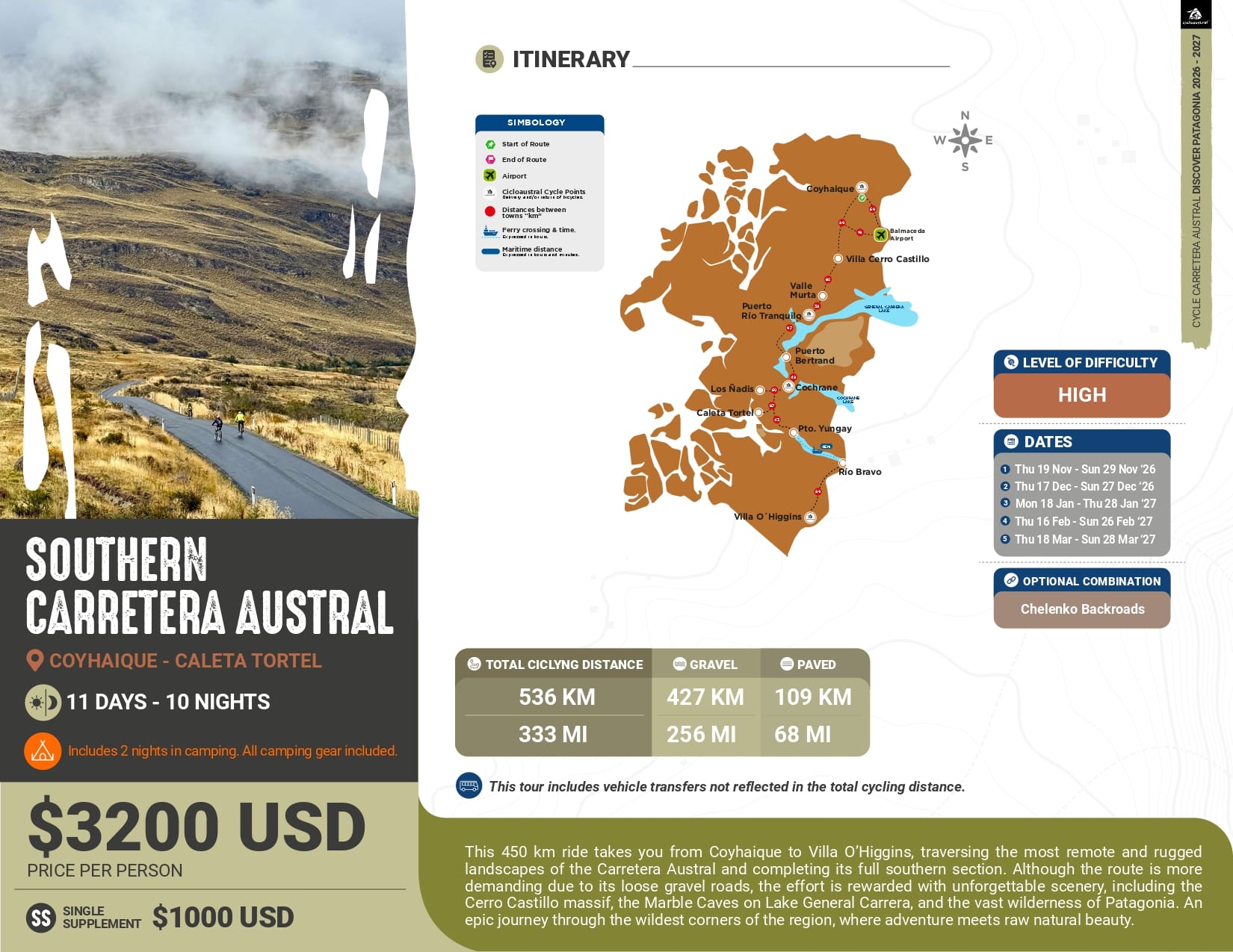
Southern Carretera Austral: this extends from Coyhaique to Villa O’Higgins.
The southern section is wilder and more remote than the north, leading cyclists through vast, untouched landscapes with fewer towns and services.
It presents a greater challenge, as most of the road is gravel, with steep climbs and long distances between settlements. The journey ends in Villa O’Higgins, where the road simply stops, reinforcing the sense of reaching one of the most isolated places in the world.
If you want support for riding the Southern Carretera Austral, here’s our Southern Tour.
You can also explore a smaller area on a shorter guided trip. Our Chelenko Gravel Backroads tour takes you from Cerro Castillo via Chile Chico to Puerto Tranquilo. It is an option to consider if you have a week available. Find out more in Part 3 below.
History
Before the 1970s, the Carretera Austral did not exist. Southern Patagonia was only accessible via east-west roads connecting towns to the sea, where ferries would transport people and goods to mainland Chile. Some rough, secondary roads existed further south, but travel was extremely difficult.
In 1973, construction of Route 7 began as part of a broader effort to promote development and national sovereignty in the region.
It is one of Chile’s most ambitious public works projects and was led by the Cuerpo Militar del Trabajo. They were faced with the enormous challenge of carving a road through dense forests, steep mountains, and wild rivers. This meant construction of the route took decades.
In 2025, the Carretera Austral was designated as a Scenic Route by the Chilean government, highlighting its significance as a cultural and natural treasure of Patagonia.
Today, the Carretera Austral remains a symbol of resilience and exploration; it is continuously evolving as new sections are improved and expanded. But it still preserves its remote and adventurous character.
Be aware! Even today, parts of the route are still unpaved. For many, this only adds to the route’s sense of adventure. More on that below.
Navigation and signposting
Despite its remoteness, the Carretera Austral is relatively easy to navigate since there is only one main road running north to south.
However, there are countless side roads leading to remote and spectacular locations. So, having a good map or GPS is highly recommended.
Be aware! Most of the route is well-signposted, but given the wild nature of Patagonia, weather conditions and landslides can sometimes affect visibility and accessibility.
For example, during the off-season (July to August), some sections may become impassable due to snow and heavy rains, so careful planning is essential. More on this below.
What are the surfaces like?
Approximately 60% of the Carretera Austral is on paved asphalt roads and 40% on gravel tracks.
The northern section of the Carretera Austral is mostly paved, except for some more challenging parts like the infamous Queulat Pass. This features over 30 tight curves and a dramatic 600 metres of elevation gain.
The southern section remains predominantly gravel. While road improvements are ongoing, much of the allure of the Carretera Austral comes from its unpaved, rugged terrain.
With a large section of the route still unpaved, the Carretera Austral has huge appeal amongst riders looking for a challenging, off-the-beaten-track adventure.
Who is the Carretera Austral for?
This route is best for riders who are used to cycling long distances.
Both the north and south sections of the route are physically and mentally demanding. But there are some key differences and things to consider:
Northern Carretera Austral
The Northern Carretera Austral is ideal for cyclists who want to experience the diversity of Patagonia while riding a combination of mainly paved and some gravel roads.
With 100 kilometres of gravel and 460 kilometres of asphalt roads, this section presents medium-high difficulty, requiring good physical condition and some experience in long-distance cycling.
Top tip! The presence of more frequent services and infrastructure makes it a good option for those seeking a balance between challenge and accessibility.
Southern Carretera Austral
On the other hand, the Southern Carretera Austral is better suited for seasoned cyclists looking for a demanding and immersive adventure.
With 430 kilometres of loose gravel and only 120 kilometres of asphalt roads, this section demands a higher level of endurance and technical skill. You should also be prepared for long, isolated stretches.
The lack of major towns and the ever-changing terrain make it an intense but deeply rewarding experience.
Regardless of the section chosen, cycling the Carretera Austral is not about convenience – it’s about embracing the unpredictable, challenging the limits of the body and mind, and discovering the raw beauty of one of the world’s last truly wild roads.
Be aware! For self-guided cyclists, careful planning is essential. You will need a bike that can cope with rough roads and that is able to carry your gear. Cicloaustral offers bike hire (and associated services) for self-supported cyclists. See more on this below.


Sponsor Message
Which Carretera Austral cycling trip is right for you?
Join a guided tour, choose a self-guided trip or hire a bike for your own adventure.
Cicloaustral was founded in 2013 and has organised Carretera Austral bike tours for over 10 years.
They have several guided bike tours along the route, including options in the north and south. You can also ride all 1,200 kilometres on a self-supported bike tour with the help of their services, such as bike hire and app navigation.
Here are their most popular itineraries!
Got a question for Claudia from Cicloaustral?
Fill out this form and we will pass it to Cicloaustral who aim to reply (within 24 hours wherever they can!)
Part 2: Why is cycling the Carretera Austral a must-do?
The Carretera Austral was named one of the top three cycling routes in the world by National Geographic in its 2010 Journeys of a Lifetime book.
What makes the Carretera Austral so extraordinary is its remoteness and hidden treasures; tucked between the towering mountains and peaceful fjords, you’ll find places unlike anywhere else on earth.
It’s an ever-changing journey through one of the last truly wild places on the planet. It cannot fail to remind you just how small you are in the face of nature’s immensity.
Wild, natural beauty
What keeps you moving is the sheer beauty of the regions you cycle through; nature remains largely untamed and untouched in this part of the world.
One moment, you’re riding along a turquoise lake surrounded by thick, green forests. The next, you’re crossing an open valley where the wind bends the grass in waves, with condors soaring overhead.
Some of the most impressive natural scenery you can expect include:
- The iconic Marble Caves (Capillas de Mármol): a stunning geological formation of swirling blue and white marble that can only be accessed by boat or kayak on the General Carrera Lake. Find out more about this highlight below.
- The Alerce ancient trees in Pumalin Tompkins National Park. Find out more below.
- The hanging glacier in the Queulat National Park. Find out more below.
Protected natural landscapes
In 2021, the Carretera Austral became part of the Route of the Parks of Patagonia.
This followed a major land donation by the Tompkins family, founders of The North Face, to the Chilean government. Their donation created new national parks to support long-term conservation.
Nearly half of Chile’s protected areas lie in the Aysén Region. The Patagonian forest here plays a key role in storing carbon, absorbing twice the amount of CO₂ per hectare than the Amazon rainforest (source).
Authentic insight into local life
Along the southern way, you’ll ride through 20 towns; each is home to brave people living in this remote and rural area who love to share their authentic traditions with visitors and at local festivals.
You may encounter an asado Chileno, a traditional BBQ or lamb on a sword over an open fire. Or perhaps some traditional Chamame dancing.
Remote and deeply rewarding ride
This is a tough and challenging route to complete; those who cycle the Carretera Austral quickly realise that Patagonia doesn’t make things easy.
For example, the weather shifts in an instant. The wind can be relentless. The road is unpredictable, switching from smooth asphalt to rough gravel and corrugated roads without warning.
But that’s exactly what makes it so special.
Cyclists typically choose this route because it’s a real and challenging adventure that reminds you what it feels like to be fully present in a place.
Be aware! The route runs through some of the most remote corners of the world, many places still untouched by human hands. This means there are long, lonely stretches where the only sounds are your tyres on the gravel and the wind in the trees.
Local hospitality
After a long day of riding, there’s nothing like the warmth of a wood stove in a roadside shelter, a plate of homemade food, or the kindness of locals who welcome travellers with open arms.
The hospitality of the people is something that stays with you long after the journey ends. In the harshest weather, when the road has tested you the most, a stranger may even invite you in for a meal and offer a place to rest.

Cycling through Chaiten (photo credit: Claudia Huepe via Cicloaustral)
Highlights of cycling the Carretera Austral
It is incredibly difficult to choose just a few highlights along the Carretera Austral, as the entire route is bursting with countless magnificent landscapes.
However, if we had to pick from over 1,200 kilometres of wild beauty, these are the must-visit places you simply cannot miss:
1. Pumalín National Park: A pristine paradise of ancient forests
One of the largest and most spectacular conservation projects in Chile, Pumalín National Park is a true paradise for nature lovers. This park was created through private conservation efforts and later integrated into the national park system.
It is home to towering Alerce trees over 3,000 years old, cascading waterfalls, lush temperate rainforests, and a dramatic coastline. Visitors can explore scenic hiking trails, such as the one leading to Chaitén Volcano, which offers panoramic views of the surrounding wilderness.
Explore Pumalín National Park on Cicloaustral’s Northern Carretera Austral tour. Find out more about the itinerary on the Cicloaustral website.
2. Queulat National Park: home of the Hanging Glacier
A place of raw and mystical beauty, Queulat National Park is famous for its Ventisquero Colgante (Hanging Glacier), a massive ice field suspended between two mountains, with waterfalls dramatically tumbling down from its edge.
The landscape here is lush and almost otherworldly; it is covered in dense Valdivian rainforest with hidden fjords, emerald-green rivers, and snow-capped peaks. The short hike to the glacier’s viewpoint is one of the most rewarding experiences on the Carretera Austral.
Top tip! Near the National Park lies Puyuhuapi, a small German-influenced town. You can find several hospitality services and hot springs to relax in front of the fjords. The slopes of the Queulat Pass are located not far from this town, one of the main uphill/downhill challenges of the Carretera Austral.
Visit Queulat National Park as part of Cicloaustral’s Northern Carretera Austral tour. Visit the Cicloaustral website for details of the trip.
3. Cerro Castillo National Park: Patagonia’s hidden jewel
Often compared to Torres del Paine National Park, but far less crowded.
Cerro Castillo National Park is a dream for trekkers and mountaineers. The park is dominated by the spectacular Cerro Castillo, a jagged, castle-like mountain that rises dramatically above turquoise glacial lakes. The multi-day trek through this park is one of the most challenging and rewarding hikes in Patagonia, offering breathtaking views of glaciers, valleys, and rugged peaks.
Cycling on Route 7, you encounter the great Devil’s Slope downhill, which boasts a majestic panoramic view of the Castle Mountain, before reaching Cerro Castillo Village.
Cycle through the Cerro Castillo area on Cicloaustral’s Southern Carretera Austral tour. Find out more about the route on the Cicloaustral website.
4. Marble Chapels: Nature’s masterpiece on General Carrera Lake
The Marble Chapels (Capillas de Mármol) are one of the most unique geological formations in the world. These magnificent white and blue marble caves have been shaped by thousands of years of wave erosion.
Cyclists can take a break from cycling and either access the Marble Chapels by boat or by kayaking on the vibrant turquoise waters of General Carrera Lake.
Cicloaustral’s Southern Carretera Austral tour offers the option to visit the Marble Chapels. Visit the Cicloaustral website for the itinerary and details of this optional excursion.
5. Patagonia National Park
Before reaching Cochrane, the Carretera Austral connects with Route X-83, which crosses the stunning Chacabuco Valley, now part of Patagonia National Park. This vast park, spanning over 300,000 hectares, was created through a public–private effort, merging the Tamango and Jeinimeni reserves with lands donated by the Tompkins family, who transformed the valley into a conservation area. It protects large expanses of Patagonian steppe, where guanacos and condors roam freely, and in the Tamango sector, visitors may spot the endangered huemul.
Other highlights include the Tamango River, Lago Tamango, and the surreal Lunar Valley, located near Chile Chico. Due to the park’s large extension and the distance between its sections, visiting it requires good planning, extra travel days, and the willingness to cover long distances to fully appreciate its diverse landscapes.
Explore Patagonia National Park as part of Cicloaustral’s Southern Carretera Austral tour. Find out more about the places visited on the Cicloaustral website.
6. Caleta Tortel: A village with no streets, only wooden walkways
At the southern end of the Carretera Austral lies Caleta Tortel, a charming and unique coastal village where there are no traditional streets. Instead, you’ll find an intricate network of wooden walkways built over stilts made by the Guaiteca’s cypress tree.
The entire town sits harmoniously within the surrounding fjords, mountains, and forests, offering a peaceful and off-the-beaten-path experience.
Walking through Tortel feels like stepping into a different world, where time slows down and nature takes centre stage. It’s little wonder it was named one of the “Best Tourism Villages” by the UNWTO in 2023 (source).
Visit Caleta Tortel on Cicloaustral’s Southern Carretera Austral tour. Find out more about the itinerary on the Cicloaustral website.

Cycling the Carretera Austral (photo credit: Gregory Allen Levo via Cicloaustral)
Sponsor Message
Which Carretera Austral cycling trip is right for you?
Join a guided tour, choose a self-guided trip or hire a bike for your own adventure.
Cicloaustral was founded in 2013 and has organised Carretera Austral bike tours for over 10 years.
They have several guided bike tours along the route, including options in the north and south. You can also ride all 1,200 kilometres on a self-supported bike tour with the help of their services, such as bike hire and app navigation.
Here are their most popular itineraries!
Got a question for Claudia from Cicloaustral?
Fill out this form and we will pass it to Cicloaustral who aim to reply (within 24 hours wherever they can!)
Part 3: The Carretera Austral route with Cicloaustral
Cicloaustral has organised cycling trips along the Carretera Austral. We offer guided tours, self-guided trips and tailor-made options. Riders travelling independently can also arrange bike hire, accommodation bookings and other services. From 2027, self-guided departures will offer daily luggage transfers, bookable separately or alongside a B&B or hotel package.
Below, we follow our self-guided itinerary for the full route from Puerto Montt to Villa O’Higgins. You can also ride the Northern Carretera Austral or Southern Carretera Austral separately. Guided and tailor-made trips may follow different stages, with accommodation and support depending on the option you choose.
The itinerary below describes Cicloaustral’s self-guided route. Guided and tailor-made itineraries may use different stages. Accommodation and other additional services are not included unless stated otherwise.
Northern Carretera Austral: Puerto Montt or Puerto Varas to Coyhaique
Cicloaustral offer Northern Carretera Austral tours on a guided tour, self-supported tour or a tailor-made basis. The routes and itineraries will vary for each. There are more details on each service below.
GPX DownloadTerms of use reminder
Day 1: Puerto Montt or Puerto Varas to Contao
Distance: 64 kilometres / 40 miles from Puerto Montt; 84 kilometres / 52 miles from Puerto Varas
Road surface: asphalt
Destination: Contao
What to expect
From Puerto Montt or Puerto Varas, you will head towards kilometre zero of the Carretera Austral in Puerto Montt. The route then leaves the city and enters the rural area near Alerce Andino National Park.
At Caleta La Arena, you will take the ferry across the Reloncaví Estuary to Caleta Puelche. The final 10 kilometres lead to Contao on the coast. On a clear night, you may be able to see the lights of Chiloé Island across the water.
Day 2: Contao to Hornopirén
Distance: 48 km / 30 miles
Road surface: asphalt
Destination: Hornopirén
What to expect
From Contao, you have two possible routes to Hornopirén. You can remain on Route 7, which has more frequent climbs, or take the longer coastal road through the rural Hualaihué area.
Both options pass forest and coastal areas before reaching Hornopirén.

Exploring Pumalin National Park (photo credit: Cicloaustral)
Day 3: Hornopirén to Caleta Gonzalo/Chaitén
Distance: 65 kilometres / 40 miles
Road surface: gravel and asphalt
Destination: Pumalín National Park or Chaitén
What to expect
The day begins with the ferry journey along the Bimodal Route. The first crossing takes approximately three and a half hours through the fjords of northern Patagonia.
After disembarking, you will ride approximately 10 kilometres before taking a second ferry. This crossing takes around 45 minutes and arrives at Caleta Gonzalo in Pumalín Douglas Tompkins National Park.
From Caleta Gonzalo, you can cycle through evergreen forest and stop to walk among the ancient alerce trees. The route then continues along gravel roads and past several lakes towards Chaitén.

The iconic suspension bridge in Yelcho (photo credit: Cicloaustral)
Day 4: Caleta Gonzalo/ Chaitén to Puerto Cárdenas or Villa Santa Lucía
Distance: 51 kilometres / 31 miles from Chaitén to Lago Yelcho
Road surface: asphalt
Destination: Puerto Cárdenas, Lago Yelcho or Villa Santa Lucía
What to expect
The route continues through the El Amarillo sector of Pumalín National Park. It then reaches Puerto Cárdenas and the Yelcho suspension bridge, where you can look across the mouth of the lake towards Yelcho Glacier.
You can stay around Puerto Cárdenas or Lago Yelcho. You may also continue to Villa Santa Lucía, depending on the distance you want to cover.
Day 5: Puerto Cárdenas or Villa Santa Lucía to La Junta
Distance: 89 km / 55 miles
Road surface: asphalt
Destination: La Junta
What to expect
This is one of the longer stages in the northern section. The route passes native forest and crosses the Moraga climb before descending towards Villa Santa Lucía.
A major landslide changed the landscape around Villa Santa Lucía in 2017. From here, the road follows the Frío and Palena rivers into the Aysén Region. It passes Villa Vanguardia before reaching La Junta.

Puyuhuapi (photo credit: Gregory Allen Lebo via Cicloaustral)
Day 6: La Junta to Puyuhuapi or Queulat National Park
Distance: 50 km / 31 miles
Road surface: asphalt
Destination: Puyuhuapi or Queulat National Park
What to expect
The route follows the Risopatrón River and lake towards Puyuhuapi. The town is known for its waterfront, carpet-making tradition and architecture influenced by German settlers.
You can stay in Puyuhuapi or continue towards the Hanging Glacier area of Queulat National Park. Other possible activities include visiting the hot springs, walking to the glacier viewpoint or taking a boat across Témpanos Lagoon.
Day 7: Puyuhuapi or Queulat National Park to Villa Amengual
Distance: 67 km / 42 miles
Road surface: gravel before and on the climb to Queulat Pass; paved from Queulat Pass onwards
Destination: Villa Amengual
What to expect
Today you will cross Queulat Pass. Its 33 bends make this one of the main climbing challenges on the Carretera Austral.
The route climbs through evergreen forest, with views towards glaciers and fjords. From the pass, you will descend towards the Cisnes River and continue to Villa Amengual.
Day 8: Villa Amengual to Villa Mañihuales
Distance: 60 km / 37 miles
Road surface: loose gravel and asphalt
Destination: Villa Mañihuales
What to expect
From Villa Amengual, the route passes through Las Torres National Reserve. You will cycle between rivers, forest and geological formations as the surroundings begin to change towards Patagonian steppe.
The route also passes agricultural land, Laguna Esponja and views towards Cerro El Colmillo before reaching Villa Mañihuales.
Day 9: Villa Mañihuales to Coyhaique
Distance: 80 km / 50 miles
Road surface: asphalt and gravel
Destination: Coyhaique
What to expect
The day begins on asphalt before joining a more demanding gravel road. You will cross bridges and pass mountains, rivers and the rural area around Villa Ortega.
The final section approaches Coyhaique beneath Cerro Mackay. Coyhaique is the capital of the Aysén Region and marks the end of the northern section.
Day 10: Rest day in Coyhaique (End of Northern Carratera Austral)
Distance: 0 km
Destination: Coyhaique
What to expect
We suggest using this day to rest, check your bike and buy supplies for the southern section. You can also explore Coyhaique or arrange an excursion from the city.
If you are finishing the Northern Carretera Austral in Coyhaique, Balmaceda Airport is around one hour away. From there, you can fly back to Santiago, with several flights operating each day. It is also possible to travel via Puerto Montt and continue towards Punta Arenas or Puerto Natales for onward travel to the Magallanes region and Torres del Paine National Park. DAP Airlines also operates a weekly flight from Balmaceda to Punta Arenas, which can provide onward connections towards Tierra del Fuego, Antarctica or Torres del Paine.
For more information about riding this section with a guide, visit Cicloaustral’s website to find out about its Northern Carretera Austral tour.
Southern Carretera Austral: Coyhaique to Villa O’Higgins
The Northern Carretera Austral itinerary finishes in Coyhaique, where the Southern Carretera Austral itinerary begins. We have continued the day numbering for cyclists riding both sections. You can also ride either section separately: if you are starting in Coyhaique, day 11 below becomes day 1 of your Southern Carretera Austral trip.
Explore Cicloaustral’s Northern Carretera Austral tour and Southern Carretera Austral tour for details of their itineraries and included services.
Day 11: Coyhaique to Laguna Chiguay/Villa Cerro Castillo
Distance: 93 km / 58 miles
Road surface: asphalt
Destination: Villa Cerro Castillo
What to expect
The southern section begins on asphalt through the countryside outside Coyhaique. You will pass rock formations known locally as the Chinese Wall before reaching El Blanco.
After the junction between Route 7 and the road to Balmaceda, the road begins to climb towards Laguna Chiguay. This is a possible place to camp or stop for lunch.
The route then crosses Cerro Castillo National Park and reaches the highest road point on the Carretera Austral. The descent known as the Devil’s Slope leads towards the Ibáñez River viewpoints and Villa Cerro Castillo.
Day 12: Laguna Chiguay/Villa Cerro Castillo to Murta Valley
Distance: up to 81 km / 50 miles
Road surface: asphalt, loose gravel and corrugations
Destination: Murta Valley or Puerto Río Tranquilo
What to expect
The asphalt ends approximately 15 kilometres after Villa Cerro Castillo. From here, the route becomes more demanding, with loose gravel and corrugated sections.
You will pass Laguna Verde and the Dead Forest beside the Ibáñez River. This landscape was affected by ash from the 1991 eruption of Hudson Volcano.
Before reaching the Murta Valley, you will cross another significant climb. You can camp in the Traihuanca area or continue to Puerto Río Tranquilo if you have enough time and experience. Accommodation and camping options are limited along this section.
Day 13: Murta Valley to Puerto Río Tranquilo
Distance: 38 km / 23 miles
Road surface: loose and corrugated gravel
Destination: Puerto Río Tranquilo
What to expect
The route begins in the Murta Valley before crossing the Belga climb. It then reaches the turquoise water of General Carrera Lake, the second-largest lake in South America.
The road continues beside the lake, with a succession of shorter climbs and descents, before reaching Puerto Río Tranquilo.
From the town, you can arrange a boat or kayak trip to the Marble Caves. The Exploradores Valley and Exploradores Glacier are other possible excursions from Puerto Río Tranquilo.
Day 14: Puerto Río Tranquilo to Bahía Catalina or Puerto Bertrand
Distance: 73 km / 45 miles
Road surface: loose gravel
Destination: Bahía Catalina or Puerto Bertrand
What to expect
The route follows General Carrera Lake, which is also known as Chelenko. Across the water, you can see valleys and glaciers descending from the Northern Patagonian Ice Field.
After crossing the General Carrera bridge, you will follow the Baker River. You can stay around Bahía Catalina or continue past the junction for Puerto Guadal and Chile Chico.
The final section includes a succession of climbs and descents before reaching Puerto Bertrand.
Day 15: Puerto Bertrand to Cochrane
Distance: 51 km / 31 miles
Road surface: gravel, followed by asphalt
Destination: Cochrane
What to expect
The route follows the Baker River through an area where forest gives way to Patagonian steppe and open grassland.
You can stop for a short walk to the confluence of the Baker and Nef rivers. The route then passes near Patagonia National Park, where you may see guanacos and other native wildlife.
The final section into Cochrane is on asphalt.
Day 16: Cochrane to Los Ñadis or Lago Vargas
Distance: 75 km / 47 miles
Road surface: asphalt and gravel
Destination: Los Ñadis or Lago Vargas
What to expect
The day begins on asphalt before continuing onto gravel. The route passes Esmeralda, Juncal and Chacabuco lakes, with views towards Mount San Lorenzo.
You will then return to native forest before descending into the Los Ñadis Valley. Families in this remote area continue to farm livestock and maintain small campsites for travellers.
You can stop at the campsite in Los Ñadis or continue through a remote rural section to Lago Vargas.
Day 17: Los Ñadis or Lago Vargas to Caleta Tortel
Distance: 51 km / 32 miles
Road surface: gravel
Destination: Caleta Tortel
What to expect
The route continues through native forest, wetlands and peatland. As you approach the coast, the Patagonian steppe gives way to evergreen forest.
Caleta Tortel is known for its network of wooden walkways made from Guaitecas cypress. These connect the houses with the civic centre and public services.
From Caleta Tortel, it may also be possible to continue by ferry towards Puerto Natales. Timetables and journey times should be checked before travelling.
Day 18: Caleta Tortel to Río Bravo
Distance: 56 km / 36 miles
Road surface: gravel
Destination: Río Bravo
What to expect
From Caleta Tortel, the gravel road climbs steadily before rejoining Route 7. The road then narrows and crosses another steep climb before descending to Puerto Yungay.
At Puerto Yungay, you will need to take the free ferry across the Mitchell Fjord. Places are allocated in order of arrival. We suggest checking the current timetable because the number of daily crossings can change.
After arriving in Río Bravo, you will ride the final kilometres to the campsite used for this stage.
Day 19: Río Bravo to Villa O’Higgins
Distance: 86 km / 53 miles
Road surface: gravel
Destination: Villa O’Higgins
What to expect
The final riding stage includes three significant climbs and crosses one of the most remote sections of the route. You will pass waterfalls, rivers, lakes and areas of Patagonian steppe.
Huemul deer and pumas live in this area, although sightings cannot be guaranteed.
If you do not want to cover the full distance in one day, you can stop at the Las Raíces camping refuge before continuing to Villa O’Higgins. This is separate from the two camping nights included in the guided southern tour, which are at Las Araucarias Camping Los Ñadis before Caleta Tortel and María’s Río Bravo Camping after Caleta Tortel.
Villa O’Higgins is the final settlement on the Carretera Austral. The road itself continues to Bahía Bahamondes, where ferries cross Lake O’Higgins towards the route to El Chaltén in Argentina.
Day 20: End of the bike trip and return transfer
Our self-guided itinerary ends in Villa O’Higgins. Returning to Coyhaique or Balmaceda Airport can be difficult because public transport is limited and buses may not have space for bicycles.
We now offer an additional minibus transfer from Villa O’Higgins to Coyhaique or Balmaceda Airport. The road journey can take two days.
For details of return transfers from Villa O’Higgins, including dates, bicycle transport and prices, find out how Cicloaustral can help on the Cicloaustral website.
More information
Cicloaustral also offers guided trips along the southern Carretera Austral.
Accommodation is included on our guided bike tours. For self-guided riders using the luggage shipping service, accommodation can be added on request, with Cicloaustral handling the bookings along the agreed itinerary. We can also arrange accommodation for bike hire customers following a structured itinerary. Riders who prefer to camp or decide their daily distances as they go will need to organise their own accommodation.
Visit Cicloaustral’s website for more details of the itinerary, accommodation and support provided.
Tips for riding the Carretera Austral
The itinerary above provides an outline of the main stages. However, we suggest allowing between 22 and 25 days to ride the full 1,247-kilometre Carretera Austral. This gives you time to travel between settlements, use local accommodation and explore places along the route.
- We always suggest you consider adding two more days than initially planned in case of bad weather. It also enables you to take rests when needed and experience additional activities along Route 7, such as hikes or kayaking. More on this below.
- Of course, you could cut things shorter and just ride the Northern or Southern sections. We offer guided, self-guided and tailor-made options. The precise stages, accommodation and support depend on the option you select.
- Our new 2026/2027 guided tour of the southern Carretera Austral now continues to Villa O’Higgins. The final section involves two nights of camping because conventional accommodation is extremely limited.

A river raft at Puerto Aysén (photo credit: Cicloaustral)
Guest testimonials
Everyone knows the magnificent scenery that is possible to see in videos and photos. But I think the staff and Cicloaustral really make the difference being almost perfect. The scenery is always going to be there, but the difference is how they design and make the trip. They have met our expectations.” Montse, Chile
I think the climbs were really difficult for me because I’m not that fast, but Patagonia showed me that every steep metre was worth it. As the mountains reveal a fantastic view. No matter how fast you are, because nature has been there for centuries. And so, what is ten minutes faster or slower? I felt very small next to it.” Isa, Germany
I came for a personal challenge and a dream to fulfill. To show my loved ones that with dedication and effort, day-to-day problems can be overcome. I came alone and did not know the rest of the group. But the dynamic was very good, I experienced a lot of empathy, solidarity and camaraderie.” Sergio, Chile
I expected to see things, such as the hanging glacier or maybe the Puma, at some point in the trip. But it’s not until you see them physically that you realise how huge they are. That is part of the grandness of this place. It’s the fact that there is so much of it and that it just seems to go on forever, which really struck me.” John, UK
Sponsor Message
Which Carretera Austral cycling trip is right for you?
Join a guided tour, choose a self-guided trip or hire a bike for your own adventure.
Cicloaustral was founded in 2013 and has organised Carretera Austral bike tours for over 10 years.
They have several guided bike tours along the route, including options in the north and south. You can also ride all 1,200 kilometres on a self-supported bike tour with the help of their services, such as bike hire and app navigation.
Here are their most popular itineraries!
Got a question for Claudia from Cicloaustral?
Fill out this form and we will pass it to Cicloaustral who aim to reply (within 24 hours wherever they can!)
Part 4: Planning your Carretera Austral cycle trip
Practicalities of cycling the Carretera Austral
How challenging is the riding?
The Carretera Austral is a long and demanding route. The level of difficulty also changes between the northern and southern sections.
The northern section, from Puerto Montt to Coyhaique, is about 600 kilometres. Most of this is medium difficulty. However, the tough climbs at Moraga and Queulat make these stages more challenging.
The southern section, from Coyhaique to Villa O’Higgins, is also around 600 kilometres. This section is more advanced and includes long distances between towns, loose gravel, and corrugated roads, which make it physically and mentally harder
Considering the difficulties of the road, it is recommended you train before cycling the route. See more on this below.
Can everyone cycle the Carretera Austral?
You should be in good physical condition before attempting the route. We suggest training on rides of more than 50 kilometres to develop your endurance. You should also practise riding climbs to build your strength.
If you are planning a self-guided trip, you will need to prepare your bike and cycle-touring equipment carefully. You should also plan where you will find accommodation, food and other services along the route.
If you are not an experienced touring cyclist and want to take on the challenge, there are some options to consider:
- Cicloaustral offers guided bike tours with full services. This includes accommodation, meals, picnic stops, and vehicle support to carry your luggage. You can find out about our guided bike tours on this page of the Cicloaustral website.
- Another option is to rent a mountain bike or gravel bike from us. This means you do not have to transport your own bike or arrange mechanical support before your trip. There’s more information on bike rental here.
- E-bikes are also available to rent. These have opened the route to a wider range of people. For example, Cicloaustral has supported senior riders over 80 years old to complete the route using e-bikes.

A slope through Queulat National Park (photo credit: Claudia Huepe via Cicloaustral)
Is it suitable for families with children?
Some families cycle the Carretera Austral, especially the Northern section, with children (even young children). It is challenging but possible with good organisation and support.
Cicloaustral offers self-supported family bike trips, with bike and trailer rental, accommodation bookings, and phone assistance during the trip. Visit Cicloaustral’s website to find out more and enquire about a family cycling trip.
How busy is the route?
The cycling season begins in September. The number of riders increases through spring and is highest during January and February. Numbers begin to fall during March, and the season generally ends in April.
Winter runs from May to August. Rain, snow, strong winds and colder conditions mean that very few cyclists attempt the route during these months. More on this below.
Cycle tourism along the Carretera Austral has grown since 2017. Numbers dropped during the Covid-19 pandemic but have increased again in recent years. (Source)
Data from the Puerto Montt to Chaitén and Hornopirén to Caleta Gonzalo ferry crossings recorded 923 bicycles in 2023, 963 in 2024 and 973 in 2025. A further 1,038 bicycles were carried between January and March 2026. While these figures do not include every cyclist using the Carretera Austral, they indicate continued growth. (Source)
What is the traffic like?
Be aware! Since there is no dedicated cycling lane, those biking the route sometimes travel alongside cars, trucks, and buses, particularly during peak season, although this is still usually minimal traffic. On average, there are approximately five cars, trucks or buses per hour. However, on the southern Carretera Austral, there could be even less, especially in the last part after Cochrane to the south which is more remote.
Cyclists need to stay alert and ride on the right-hand side of the road. Being visible and cautious is key.
If you are not confident riding in traffic, a guided tour can be a good option. Support vehicles and experienced guides offer added safety, assistance, and peace of mind – so you can focus on enjoying the ride without the stress of planning or navigation.
When to cycle the Carretera Austral?
Weather
Weather along the Carretera Austral is generally unpredictable.
The region’s geography – the Andes mountains, fjords and coastline – creates sharp contrasts in climate. This means you can get sunshine, rain and wind all in one day.
The west coast and western slopes of the Andes are cool and receive a lot of rain all year. Annual rainfall can reach over 7,000 millimetres. Temperatures are low, averaging 8 to 9°C. In contrast, inland areas like Coyhaique and Balmaceda are colder and drier. Rainfall is much lower, and winters can be harsh with snow and strong winds.
Whatever the location, riders should be ready for rapid changes in weather. Waterproof gear and layered clothing are essential. Find out more about what to pack below.
Best time to ride
The best time to cycle the Carretera Austral is from October to March. January is usually the warmest and most settled month. Whilst rain is less intense during this period, you should still be prepared for sudden weather changes.
January to February is the peak season for cyclists and other travellers on the route. Planning ahead is important during this time, as some accommodation has limited availability. However, even during this peak season, the Carretera Austral never feels overcrowded.
Be aware! Outside of the main riding season, the weather can be extreme. Temperatures drop below freezing, and roads can be icy and dangerous. Strong winds and snow are also common. Parts of the route, like Queulat Pass, may also close and many restaurants and places to stay also shut in the off-season.

Queulat National Park (photo credit: Claudia Huepe via Cicloaustral)
Where to stay?
Remember to double-check bike storage arrangements (and any other services you need) before booking your accommodation as policies often change and they may charge for storage.
Accommodation along the Carretera Austral is simple but welcoming.
Most places are family-run with basic facilities that offer rustic character. Whilst luxury is rare, the experience can still feel special. Some typical options include:
- Cosy wood cabins with log stoves
- Beautiful lodges by scenic lakes and rivers
- Hidden refuges in remote forest settings
- Small, comfortable hotels in towns with views of volcanoes
- Shared rooms in hostels for budget travellers
- Scenic campsites surrounded by nature
Generally, most accommodation is also used by cyclists, with many offering bike storage and small repair areas. While not officially certified as bike-friendly, they are generally welcoming and helpful.
Is it easy to find accommodation?
Be aware! Availability is limited. In January and February, places also book out quickly, and it can be hard to find good last-minute accommodation during this time.
Some guesthouses are also not listed online, so it can be difficult to make reservations in advance. It is best to do your research and plan ahead where possible.
Joining an organised tour is worth considering if you are concerned about organising accommodation. Cicloaustral includes accommodation, meals, and luggage transfers as part of our services. This means you do not need to arrange each overnight stop yourself. You can find out more about Cicloaustral’s guided tours on its website.
Campsites
Campsites are common. Sometimes, this is the only option in more remote areas along the Carretera Austral, particularly in the far south, between Caleta Tortel and Villa O’Higgins. For example, Río Bravo has no cabins or hotels, only a basic campsite.
Wild camping is not advised. Most land is private, and permission is needed to camp legally. Designated campsites are safer, better equipped, and more respectful of the environment.
Be aware! In national parks, you can only camp in marked areas. Fires are banned outside of these zones. Breaking these rules can lead to fines or prosecution. Fires have caused major damage in the past. One tourist fire destroyed 17,600 hectares of Torres del Paine National Park in 2011–2012.
Using official campsites helps protect Patagonia’s landscapes for everyone.


Best bike for riding the Carretera Austral?
It’s best to ride either a gravel bike or a mountain bike (MTB) on this route. However, a mountain bike is better suited for the entire route, especially the southern section of the Carretera Austral, where long stretches of loose gravel make riding more challenging.
Most riders choose a mountain bike. Some brave cyclists ride the route on touring bikes without suspension, but this can be tough on sections and requires good physical strength and mental resilience.
You can hire bikes from us – more information below.
Be aware! Road bikes are not suitable for the Carretera Austral due to the large amount of loose gravel on the route.
E-bikes
E-biking is a great option if it is well-planned.
Top tip! There are no public charging stations, so it is important to reach a town each day. This means covering 60 to 70 kilometres each day.
On guided tours, Cicloaustral handles battery charging at the accommodation each night.
E-bikes can be rented for scheduled bike tours, private guided tours and self-guided bike trips with luggage shipping, but only in January and February. They are not yet available for the self-supported bike hire service.

The road between Lago Vargas and Puerto Yungay (photo credit: Claudia Huepe via Cicloaustral)
Bike hire for the route?
Cicloaustral rents bikes along the entire route, from Puerto Varas to Villa O’Higgins. You can collect and return bikes at different points.
We are also the only provider offering a bike swap from gravel to mountain bike mid-route. This is ideal for the changing conditions you will encounter.
Bike rental with Cicloaustral includes:
- Helmet
- Lock
- Water bottle
Optional extras include:
- Bikepacking bags
- Camping gear
- Child trailers
For details of the bikes, collection and return locations, and optional equipment, visit Cicloaustral’s bike hire page.


Is mechanical assistance available?
There are a few bike workshops in towns such as Hornopirén, Chaitén, Puyuhuapi, Coyhaique and Puerto Tranquilo. Outside of these places, help is limited.
Be aware! If you are riding self-supported, it is essential to know how to handle basic repairs. Especially on the unpaved sections, your bike will suffer and parts wear out quicker than when riding on asphalt. Some sections are remote, with no assistance for many kilometres. Being prepared is key.
If you’re worried, check out our guided tours here.
Are luggage transfers available?
From 2027 , we will operate new self-guided departures with daily luggage transfers during January and February.
There are two departure dates for the full Carretera Austral: 15 January and 12 February 2027.
The options cover the full 1,247-kilometre Carretera Austral and its northern and southern sections. You can book the luggage transfer service on its own or combine it with a B&B or hotel package. Bike rental is also available, although cyclists are welcome to bring their own bikes. It is also possible to ride only the northern or southern half with luggage shipping, but riders need to follow the set itinerary.
You can find more information about each option below:
- Full Carretera Austral self-guided trip
- Northern Carretera Austral self-guided trip
- Southern Carretera Austral self-guided trip
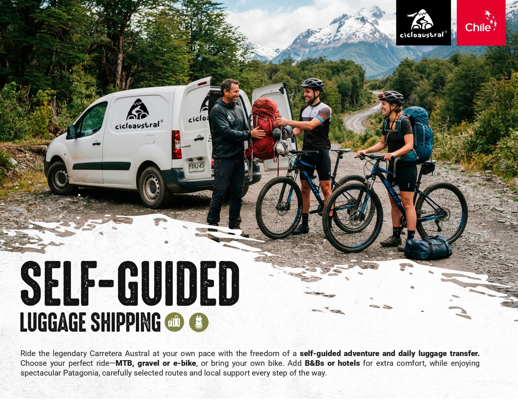
Details of our self-guided luggage shipping (photo credit: Cicloaustral)
Is food and drink available on the route?
Most villages have mini markets and small restaurants. However, you will find that the food slowly becomes more expensive and more limited as you head further south.
Be aware! Between towns, there are often no food or drink options for 60 to 70 kilometres. So, if you are cycling independently, you will need to plan ahead and carry enough supplies with you each day. There are plenty of scenic spots to stop and eat along the way.
On Cicloaustral tours, all meals are included and designed to keep you fuelled with plenty of calories and protein. This includes:
- Breakfast at your accommodation
- Picnic lunches and snacks on the road
- Dinner at local restaurants or lodges
During our bike tours, breakfast is served at the accommodation. Expect hot tea or coffee, oats with milk or yoghurt, seasonal fruit, and freshly baked Chilean bread such as marraqueta, hallulla, or kneaded bread. These are often served with avocado (palta), eggs, butter, cheese or ham. For those with a sweet tooth, homemade jam or manjar (dulce de leche) is also common.
Lunches and snacks are carefully prepared, as there are often no shops between towns. Our team sets up a picnic in a scenic spot along the route. Meals include sandwiches, burritos, fresh salads, fruit, nuts, energy bars, Chilean sweets, chocolate, juice, tea, coffee, mate (a traditional South American herbal drink made with hot water) and water. Where possible, we also visit local restaurants.
In the evenings, riders can enjoy traditional Patagonian dishes. These include cordero al palo—lamb slow-roasted on a metal spit over an open fire—served with salads and potatoes. Seafood lovers may try paila marina, salmon or hake with rice and vegetables. Empanadas filled with cheese, meat or seafood are also popular. We also organise a traditional Patagonian BBQ, with lamb cooked on a sword by local gauchos.
Italian and international meals are available too. Another Chilean tradition is Once Chilena, a light evening meal with bread, hot drinks, and savoury or sweet toppings.
Is it feasible to ride this route if you are a vegetarian or a vegan?
Vegetarian meals are generally available, though vegan options are more limited. Due to the remoteness of the region, it can be helpful to bring your favourite snacks, fruits or supplements to complement local meals.
Our guides do their best to accommodate dietary preferences, but options may be limited in small towns due to local resources and cooking practices.
Please note that travellers with coeliac conditions may struggle to find suitable food in remote areas. Gluten-free meals are difficult to guarantee outside larger towns.
Vegetarian, vegan, and special diets can be accommodated on Cicloaustral tours with advance notice.
Can you drink the water from rivers?
In Patagonia, many locals drink straight from streams fed by glaciers and mountain springs. While the water is often very pure, it is also shared by wildlife, which can introduce bacteria.
For international visitors, we recommend not drinking untreated water. To stay safe, use a water filter, purification tablets, or fill up in towns where the supply is treated.
On our guided tours, Cicloaustral provides fresh drinking water at all times through vehicle support, so you will always have safe refills available. More information on the Cicloaustral website.
What training do you suggest?
Aim to ride at least three times a week before taking on the Carretera Austral. Include rides of 50 to 100 kilometres to build up your endurance and try and do some back-to-back days of riding.
It is also important to train on climbs and descents. Uphills help build strength, while downhills improve balance and control. This will give you a solid fitness base for the route.

Cóndor (photo credit: Claudia Huepe via Cicloaustral)
Getting there and back
To start in Puerto Montt or Puerto Varas, fly into El Tepual Airport or arrive by bus. To begin halfway along the route, you can fly to Balmaceda Airport near Coyhaique.
Travelling with your bike
Be aware! There is no public transport from the airports that accepts bikes.
However, private transfers are available outside the terminals and can carry bikes with prior arrangement.
Finding somewhere to store a bike box can also be difficult. There are private transport services that can help, but they must be booked in advance.
Cicloaustral can assist by sending your bike box or luggage to your final cycle point, but this service also needs to be arranged ahead of time. More information on our self-supported page.
Returning home after finishing the route
When you reach Villa O’Higgins, the Carretera Austral ends; there is no road further south. Many cyclists continue into Argentina by taking the ferry from Villa O’Higgins and crossing the glacier pass to El Chaltén. From there, they travel to El Calafate to visit the Perito Moreno Glacier.
Some return to Chile to explore Torres del Paine National Park and continue south to Tierra del Fuego and Ushuaia.
Others choose to head back to Coyhaique and fly out of Balmaceda Airport.
Tips for getting the most from your Carretera Austral trip
What is the best direction to cycle?
Most cyclists ride the Carretera Austral from north to south.
In 2024, 44% started in Puerto Montt and 13% in Puerto Varas. Around 60% finished in either Villa O’Higgins or Caleta Tortel, with some continuing by ferry to Torres del Paine National Park. Many others ended their ride in Coyhaique, halfway along the route. (Source: Cicloaustral Chile & Padilla F. V., 2024). The Transformational Experience In Cycle Tourism: Evidence from Patagonia Chile).
The thesis is available through the university library but has not been published online. You can learn more about the research in our article on cycle tourism trends along the Carretera Austral.
Top tip! Cycling north to south offers a natural progression – from paved roads and dense rainforest in the north to remote gravel tracks and Patagonian steppe in the south. It also allows riders to adapt gradually before reaching the more challenging sections beyond Coyhaique.

The road to Puerto Bertrand (photo credit: Claudia Huepe via Cicloaustral)
Should you bring cash?
It is a good idea to carry some cash. Most supermarkets, restaurants and accommodation accept cards, but small shops and businesses in rural areas may not.
ATMs are available in larger towns. We suggest carrying the equivalent of around £160 in Chilean pesos (CLP).
Do you need to book National Park entrance fees?
If you are planning a self-guided trip, book your national park tickets in advance through the official Pases Parques website. Search for the national park you want to visit and complete the booking online. Internet access near the parks can be limited or unavailable.
Booking early is particularly important for Queulat and Cerro Castillo national parks. Tickets can be difficult to obtain during the main cycling season.
Entrance tickets are included on our guided tours and managed by our team, so you do not need to purchase them separately. More information on our guided tours is here.
Can I expect wifi access?
Mobile signal and data can be unreliable along the route, especially between towns.
Most towns offer some phone coverage, and many accommodations provide Wi-Fi, although it may be slow or limited.
For the best mobile signal, Entel has the widest coverage, followed by Movistar.
How many days do you need to ride the Carretera Austral?
To cycle the full Carretera Austral, you should allow at least 21 days, based on an average of 60 kilometres per day. We suggest planning for 25 days to account for rest stops, bad weather or time to explore national parks.
Rest days
It is worth considering taking at least two rest days along the way to rest your legs and enjoy key additional activities. Some popular excursions include:
- Hiking in Pumalín or Queulat National Parks
- Visiting the Marble Chapels
- Exploring the Exploradores Valley
Top tip! Some excursions require a guide or special transport, such as the Marble Chapels, which can only be accessed by boat or kayak. Joining a guided tour is the best option.
On our tours, activities like hiking in Pumalín and Queulat National Parks are included, and we take care of acquiring the entrance tickets for those and other parks. The itinerary also offers the option to join additional activities, such as the Marble Caves excursion (by kayak or boat) or rafting on the Baker River. These activities are optional and not included in the tour price, so they involve an extra cost. Some clients prefer to use this time to rest instead.. For clients on our self-guided tours, we can also assist with booking these kinds of activities and other additional services.
Extending your stay
Puerto Varas, just 20 minutes from Puerto Montt, is a great place to spend a few days before starting your ride. It sits on the shore of Lago Llanquihue and offers excellent tourism services.
Coyhaique is a useful midway stop to rest and restock supplies.
At the end of the Carretera Austral in Villa O’Higgins, you may need to wait a day or two for transport back to Cochrane or Coyhaique, where you can fly out of Patagonia.
If you plan to continue south toward Villa Castillo and the ferry to Argentina, allow extra time for the crossing.

Sunrise on the General Carrera Lake (photo credit: Reva Golden via Cicloaustral)
Do you need to speak Spanish?
English is not widely spoken in the Aysén Region of Chile. But locals are friendly and welcoming. Knowing some basic Spanish will be very helpful, such as:
- Hola – Hello
- Buenos días – Good morning
- Buenas tardes – Good afternoon
- Por favor – Please
- Gracias – Thank you
- De nada – You’re welcome
- Disculpe – Excuse me / Sorry
- No hablo mucho español – I do not speak much Spanish
Be aware! Chilean Spanish can be hard to understand. It is spoken quickly, with unique pronunciation and local slang. However, most tourism services do have English-speaking staff.
Is there transport along the route?
Be aware! There are several ferry crossings along the Carretera Austral, depending on your route. These connect key sections and are essential for reaching remote areas. The most complex is the bimodal ferry between Hornopirén and Caleta Gonzalo. It includes two ferry rides:
- Hornopirén to Leptepu, followed by a 10-kilometre cycle to Fiordo Largo
- Fiordo Largo to Caleta Gonzalo
Top tip! This route is very popular in peak season. We strongly suggest booking tickets at least two months in advance. Same-day tickets are almost impossible to get, and some travellers have been known to wait more than three days in Hornopirén without a reservation. To avoid delays and reduce pressure on local communities, plan ahead and secure your bookings early.
Here are some useful ferry booking links:
- Bimodal ferry (Hornopirén to Caleta Gonzalo)
- Ferries from Puerto Montt to Chaitén and other links between Los Lagos and Aysén
- Ferry from Caleta Tortel to Puerto Natales
Buses operate between some towns., but timetables can change each season. Check the latest information directly with the bus terminals. Some services carry bicycles, but space is not guaranteed and buses may not be equipped to transport them securely.
From 2027, Cicloaustral will offer self-guided departures with daily luggage transfers. You can book the luggage transfer service separately or combine it with a B&B or hotel package. Visit Cicloaustral’s website to find out more about luggage transfers and enquire about dates.
How do you return from Villa O’Higgins with a bike?
Returning from Villa O’Higgins with a bicycle can be difficult. Public buses operate on a limited schedule and may not have suitable space for bikes. The journey towards Coyhaique can also involve an overnight stop in Cochrane.
We now provide a private transfer from Villa O’Higgins to Coyhaique or Balmaceda Airport. A local pick-up truck can carry up to four passengers, together with their bikes and luggage. You can find out more on this page of our website.
The journey can be completed in one long day or divided across two days. The transfer costs USD 1,200 for the whole vehicle, rather than per passenger.
We can also assist you with ferry bookings and wider trip planning.
Should you expect to see wildlife?
Chilean wildlife is generally shy and poses little to no threat to humans.
Some of the species found in the region include:
- Puma – Very rare and avoids people
- Guanacos – Closely related to camels and llamas
- Andean condor – Large bird often seen soaring on mountain winds
- Huemul – Endangered native deer, symbol of Chile
- Pudú – Tiny, shy forest deer
- Guiña – Small wild cat
- Chucao – Friendly forest bird with a bright red chest and a melodic call
Top tip! You are unlikely to encounter dangerous animals while cycling the Carretera Austral. Most Chileans have never seen these animals in the wild. But keep your eyes open as you might spot condors, huemuls, guanacos or colourful birds along the way.
Are stray dogs an issue?
Stray dogs are very common in Chile, especially in cities and towns. Additionally, there’s a growing issue with domestic dogs that have been abandoned near protected areas, where they can pose a serious threat to native wildlife.
Sometimes, cyclists may encounter dogs on the road, especially when passing through urban areas or near homes. We recommend staying alert, and if a dog approaches aggressively, try to keep your distance, use your bike as a barrier, or try to scare it away.

Huemul (photo credit: Claudia Huepe via Cicloaustral)
What to pack?
As mentioned previously, weather conditions can change quickly on the Carretera Austral. So, it is important to be prepared for rain, sun, wind and cold. This includes bringing warm layers and a lightweight, waterproof/windproof jacket and trousers.
You should also make sure you have padded cycling shorts, some gloves and suitable sun protection, including sunglasses and sunscreen. A bandana or buff can also be useful to protect yourself from dust from the gravel roads and any construction works.
If you are cycling independently, some additional useful packing essentials include a power bank, head torch, plenty of water containers, plus a tent and your sleeping system.
For more packing essentials, don’t miss this article.
Highway code and travel information
As always, it’s a good idea to check current travel information before you book and travel. For UK visitors, the UK government travel information pages for Chile are here.
You should also read and follow Chile’s highway code.
Also, make sure you have all the recommended travel vaccinations.

Cordón Contreras – Puerto Bertrand (photo credit: Claudia Huepe via Cicloaustral)
Sponsor Message
Which Carretera Austral cycling trip is right for you?
Join a guided tour, choose a self-guided trip or hire a bike for your own adventure.
Cicloaustral was founded in 2013 and has organised Carretera Austral bike tours for over 10 years.
They have several guided bike tours along the route, including options in the north and south. You can also ride all 1,200 kilometres on a self-supported bike tour with the help of their services, such as bike hire and app navigation.
Here are their most popular itineraries!
Got a question for Claudia from Cicloaustral?
Fill out this form and we will pass it to Cicloaustral who aim to reply (within 24 hours wherever they can!)
Part 5: What does Cicloaustral offer?
Cicloaustral began with a ride, a 2,200-kilometre cycling journey through Patagonia’s Carretera Austral in 2010.
That adventure sparked a vision: to create meaningful cycling experiences in one of the world’s most remote and beautiful regions.
Founded in 2013, Cicloaustral is built on a commitment to sustainability, local connection, and a deep respect for Patagonia’s landscapes and people.
For over ten years, we have offered cycling trips that go beyond traditional tourism. Whether through guided tours or self-supported journeys, our goal is simple: to create unforgettable, low-impact adventures that connect riders with the true spirit of Patagonia.
We offer several Carretera Austral bike tours, including:
Guided bike tours
Explore the Carretera Austral with one of our scheduled guided tours from October to April. These trips include expert guides, accommodation and meals and vehicle support along the way. Choose from five different itineraries, covering both the northern and southern sections of the route. This includes:
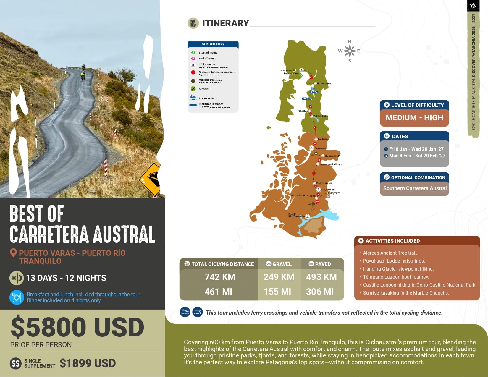
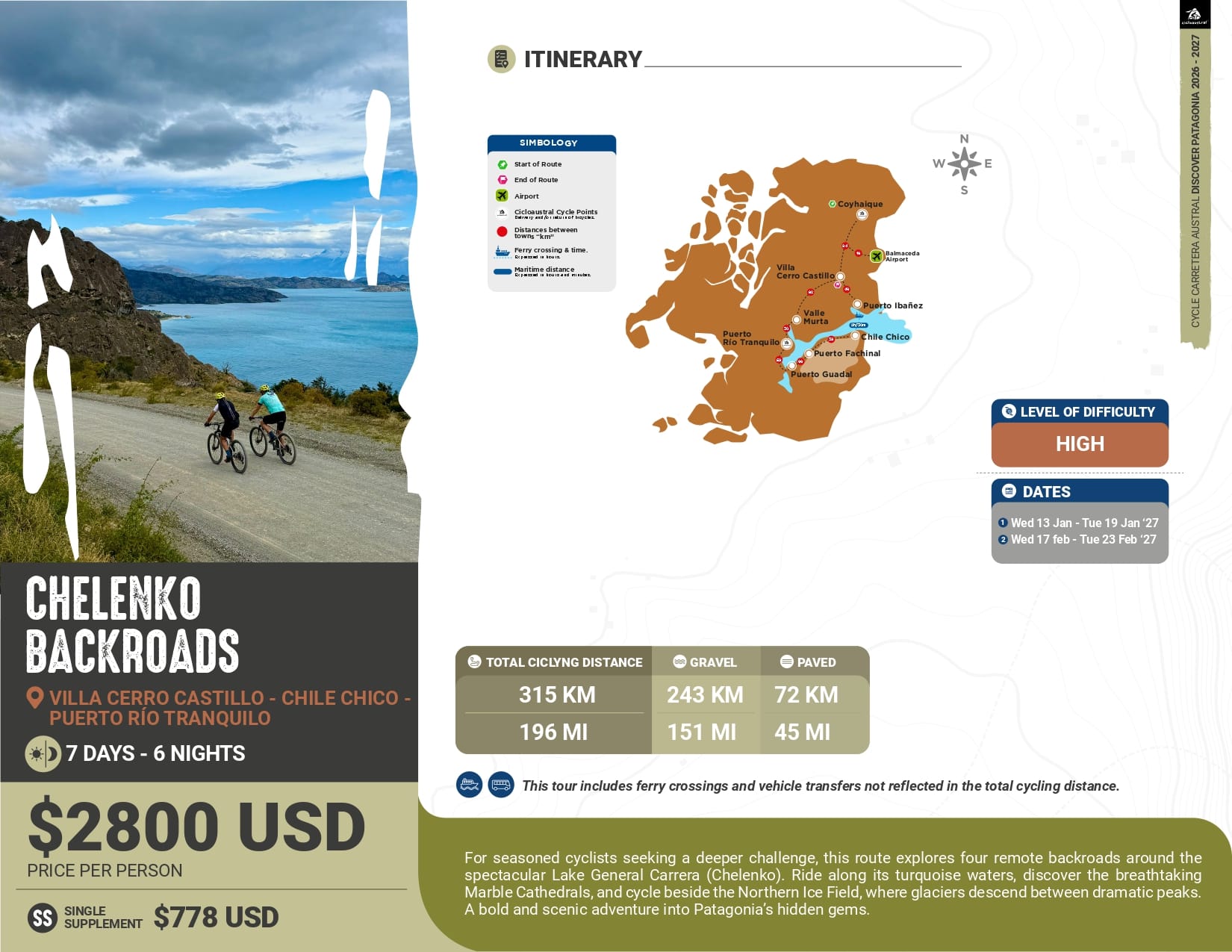
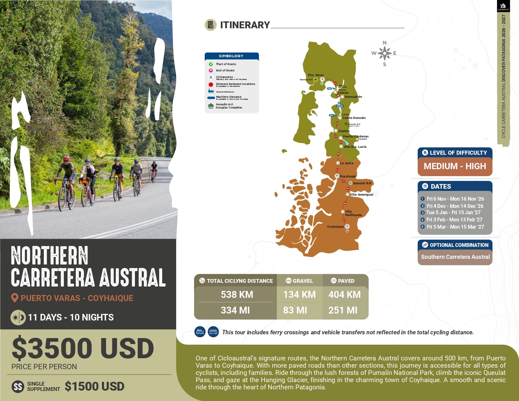
Self-supported bike trips
Ride independently with the services you need arranged in advance. Options include bike hire, navigation and luggage transfers between selected locations.
Visit Cicloaustral’s website for details of its self-guided trips and the services available with each option.
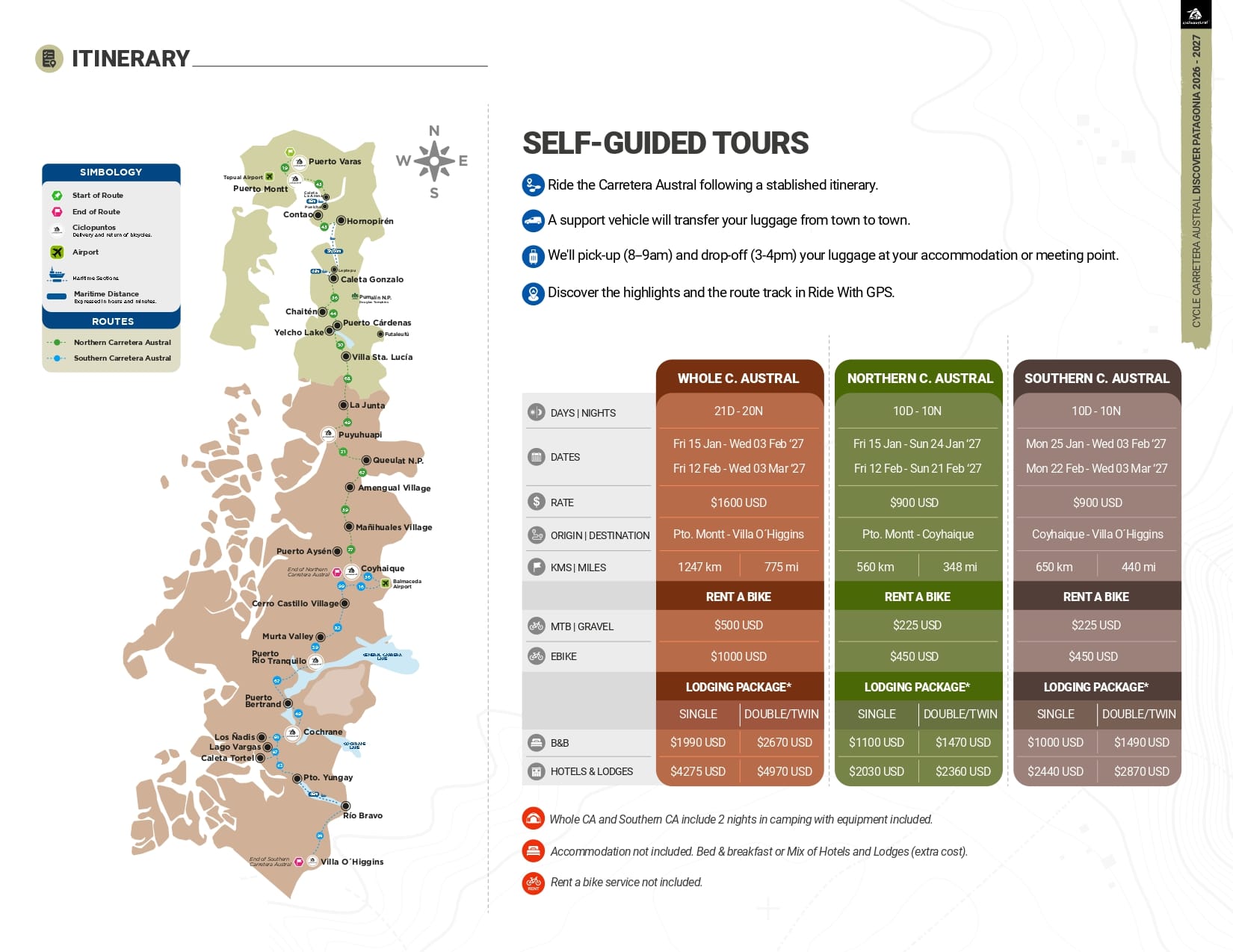
Our self guided tours (photo credit: Cicloaustral)
Tailor-made bike tours
These enable cyclists to design their own Patagonia cycling experience, customising things like the route and travel dates, style of accommodation, optional experiences and bike hire. More information here.
Bike hire only
We also offer a “bike hire only” service along the Carretera Austral. Visit Cicloaustral’s bike hire page for details of the bikes, equipment and collection points.
Where can cyclists find out more about your services?
We have been helping cyclists explore the Carretera Austral since 2013. Whether you want to join a guided tour, ride independently with support or hire a bike, we can help you plan your trip.
You do not need to have every detail decided before contacting us. Tell us when you would like to travel, how long you have and the kind of riding you enjoy. We can help you choose a section of the route and discuss the services you need.
Visit Cicloaustral’s website to explore our trips and enquire about your Carretera Austral cycling holiday. We would love to help you experience this part of Patagonia by bike.
What’s next?
A massive thanks to these detailed insights from Claudia about cycling the Carretera Austral.
We think cycling in Patagonia sounds like an incredible bucket list adventure. It’s certainly a fantastic option for anyone looking for an impressive and rewarding adventure through remote landscapes.
Looking for more inspiration? Don’t miss:
- Cycling Chile, our hub page for the country
- How to plan a Chile cycling tour: why Chile’s Lake and Volcano region is a must-visit
- Cycling South America: the Trans Andean Coast to Coast from Rat Race
- Cycling in Uruguay: the inside guide
- Cycling Vancouver to Prince Rupert (via Whistler + Vancouver Island): British Columbia, Canada itinerary
- Expert tips for planning a cycling tour in South Africa
- 5 of the best places to go cycling in January
Got a question for Cicloaustral?
Fill out this form and we will pass it to Cicloaustral who aim to reply (within 24 hours wherever they can!)
Got a question for Claudia?
Fill out this form and we will send it to Claudia. We aim to get you an answer within 24 hours where possible!Claudia Huepe is the co-founder of Cicloaustral Chile and has spent over a decade promoting the Carretera Austral as a global cycling destination. With a degree in ecotourism, she has played a key role in developing cycling experiences that connect riders with Patagonia’s landscapes and communities.
Through her work on guided tours, self-supported trips and the bike rental system, Claudia has focused on making travel both smooth and meaningful. Her goal is to create journeys that are not only memorable and immersive, but also bring lasting, positive impact to this remote and rural region.
Last Reviewed: 29 September 2026
First Published: 13 May 2025
The contents of this website are provided for general information purposes only. It is not intended to amount to advice and you should not rely on it. You should carry out your own due diligence and risk assessments and take professional advice. Views expressed by interviewees or other users of this website do not necessarily represent our views. We make no representations, warranties or guarantees, whether express or implied, that the content on our website is accurate, complete or up to date. If you use any information or content on this website, download from, or otherwise obtain content or services through our website, it is entirely at your own discretion and risk. Epic Road Rides Ltd disclaims all liability and responsibility arising from any reliance placed on the information and content on this website. Find out more here.
Sponsor Message
Which Carretera Austral cycling trip is right for you?
Join a guided tour, choose a self-guided trip or hire a bike for your own adventure.
Cicloaustral was founded in 2013 and has organised Carretera Austral bike tours for over 10 years.
They have several guided bike tours along the route, including options in the north and south. You can also ride all 1,200 kilometres on a self-supported bike tour with the help of their services, such as bike hire and app navigation.
Here are their most popular itineraries!
Got a question for Claudia from Cicloaustral?
Fill out this form and we will pass it to Cicloaustral who aim to reply (within 24 hours wherever they can!)
Comments