
While you’re unlikely to ever base yourself in central San Francisco for a pure cycling holiday, San Francisco’s biking opportunities abound.
Cycling campaigners have done a lot to improve the inner city experience but what’s really incredible is the cycling you find in the wider San Francisco Bay area, in places like the Marin Headlands, Sausalito, Tiburon and West Marin.
In this article, we speak with Sarah Llewellyn, a Brit who has lived in San Francisco for 25 years. She’s finally leaving the city and, before she heads back home, has kindly taken the time to share all her best tips for cycling San Francisco.
Below you’ll find in-depth information on San Francisco bike routes, bike shops and where to stay in San Francisco. We hope it helps you plan a fantastic trip.
Sarah has also written about her experience crewing on RAAM Race Across America.

Sarah Llewellyn is a cyclist from the UK who has lived in San Francisco for many years. She says "When my husband and I moved from London to San Francisco in 1997, we told our families we’d be gone between three and five years. But more than 25 years later, we're still here! The Bay Area has so much natural beauty and so much to offer in terms of outdoor activities that we have never stopped reminding ourselves how lucky we are to live here.
I’m also fortunate to work as a freelance translator (French into English) so have lots of flexibility with my work schedule and am the first to admit that I typically fit work around cycling, rather than the other way around.
I nearly always ride during the week because weekends tend to be very busy. I typically choose routes with very little traffic but not so remote that if, heaven forbid, something were to happen, there wouldn’t be someone passing by to help. Actually, solo riding among women is very common here."
What’s biking San Francisco like?
What I love most about biking in San Francisco and the surrounding area is the incredible variety of scenery. Here in the Bay Area, we have a magnificent coastline, beautiful beaches, redwood forests, hills, rural farmland, state parks, lakes, reservoirs, lagoons, more hills, marshland, historic towns, sparkling yacht harbours and lots, lots more. And better still, many of these sights can be combined in a single ride.
The famous San Francisco hills
Cycling in the Bay Area is pretty challenging because of the hills. There are some short, flat bike paths that work brilliantly for families, but if you want to get out to see the real beauty of the area, you have to be prepared to do some climbing.
Some climbs are long, but they are all so scenic and beautiful that you almost forget the suffering in your legs. And there is nothing so steep as to make a seasoned cyclist dismount.
Your Garmin might register 14% in a few spots, but so fleetingly that you won’t even notice, apart from the burn in your legs. I’d say anyone with a good level of fitness can tackle any of the iconic San Francisco bike rides, but there’s also a good variety of more moderate routes for the recreational cyclist.
And most importantly, there’s always a great café (or two or three) on every ride, and no shortage of toilets and drinking water stops.
Cycling Marin County
Most of the riding I do is in Marin County, although I’ll sometimes drive an hour south or an hour north to start a ride a bit further afield. There’s also a fantastic train service (the SMART train) that starts in Marin (at Larkspur Landing) and goes all the way to Sonoma County, offering a further selection of rides, such as around the wine country or a one-way route back to your starting station via the backcountry roads of West Marin.
 View of the Golden Gate Bridge from Fort Point
 Striking views of San Francisco
  The Bay Area offers incredible coastal vistas
Must-do bike routes in San Francisco (and beyond)?
When thinking about the best bike rides in San Francisco, it depends whether you want to see more of the city itself or the stunning surrounding countryside.
Routes from the city
Below you’ll find my favourite four routes from the city. The links take you to more information at the bottom of the article – I’ve written quite a lot about each ride!
Route 1: Ocean Run
Route 2: Marin Headlands
Route 3: San Francisco to the Ferries
Route 4: Stinson Beach, Bolinas and Mt Tam
Of these my all-time favourites are the Marin Headlands and Stinson Beach rides, which involve quite a bit of climbing (less so for the Headlands) but are absolutely spectacular.
If I want a chill-out ride, I’ll do what’s known as the Tiburon Loop (which is part of the San Francisco to the Ferries (route 3 below)).
Routes further afield
My other favourite semi-local bike tour destinations are Point Reyes Station, Marshall and Tomales in West Marin (Route 5 below).
Point Reyes Station is doable from the city, but you’re talking over 70 miles round trip and almost 6,000 feet of climbing, depending on which way you come back (I’d go through Fairfax and back via Highway 1).
If I’m doing a West Marin ride, I put my bike in the back of the car and drive over the bridge so I can do a comfortable 100-kilometre loop.
If you have a car and plan to leave from Marin, there are four ideal spots to park, depending on where you’re headed. All offer ample free parking. They are:
- Sausalito behind Mike’s Bikes (1 Gate 6 Road)
- The overflow car park at The Village at Corte Madera (1618 Redwood Highway)
- Miller Creek Road opposite Marinwood Creek Playground, or
- McInnis Parkway next to the Marin Civic Center SMART station (if you’re doing a train ride).
 Golden Gate Bridge rising above the fog on Conzelman Road (see route 2 below)
- biking san francisco") View from the north side of Hawk Hill (see route 2 below)
View from the north side of Hawk Hill (see route 2 below)- biking san francisco") On Bunker Road (route 2 again!)
On Bunker Road (route 2 again!) Tell us about the main road cycling events in the area
When it comes to local cycling events, Mikes Bikes, which has stores all over the Bay Area, organises weekly rides in the summer (for example Col du Pantoll out of the Sausalito store) as well as a New Year’s Eve ride.
Sports Basement, located in The Presidio, also leads an occasional group ride, typically on a Sunday.
I recently learned that inGamba organises a few free local, shortish rides over the winter, guided by former cycling pros as an introduction to their California tours. Apparently you can be any standard – just don’t go in the fast group unless you’re really fast!
The Marin County Bicycle Coalition runs an annual Century ride in the summer, when the weather can be extremely hot. From March 2022 they will also run an annual women’s road bike event called the Jane Fondo. Described as a “ladies-only road fondo in West Marin celebrating the amazing food, beautiful scenery and rustic hospitality of the North Bay”, the ride will offer three route options of 25, 40 and 75 miles.
Jens Voigt organised a Jensie Gran Fondo several years in a row, but that was pre-Covid and I’m not sure if or when it will come back.
There’s also an annual road bike event just south of San Francisco in the Los Altos Hills called The Sequoia. I participated in it about eight years ago and it was very well organised. It has four route options, ranging from about 30 miles to a century. I’ve actually cycled most, if not all, of the roads featured in the event at some point or other and they are absolutely incredible. I highly recommend this area for cycling, especially Tunitas Creek Road and the magical King Mountain.
 View from Hawk Hill over the Golden Gate Bridge (route 2 below) – photo credit: Ariel Rabin
 Fort Funtston Lookout (route 1 below)
 View from Lincoln Boulevard (route 1 below)
Where to stay in San Francisco?
If you’re coming to the Bay Area specifically for cycling, you could either base yourself in the city within easy cycling distance of the Golden Gate Bridge, or look for something over the bridge in Marin.
Where to stay near SF
Anywhere in Sausalito, Mill Valley, Larkspur, San Anselmo or Fairfax would work well.
If you’re coming in the summer, consider basing yourself north of Mill Valley and definitely avoid San Francisco unless you love wearing thermals and winter woollies in July and August. Most of the best bike trails in San Francisco are outside the city itself, so you aren’t missing out by basing yourself slightly further afield.
In San Francisco, Laurel Inn, Inn at the Presidio and Lodge at the Presidio are bike-friendly and well positioned for bike routes. At the time of writing, they allow you to keep your bike in your room – other than The Laurel Inn which has a lockable storage unit downstairs that’s manned 24 hours.
444 Presidio Avenue, San Francisco, CA 94115
Tel: +1 415-567-8467
42 Moraga Avenue, San Francisco, CA 94129
Tel: +1 415-800-7356
105 Montgomery St, San Francisco, CA 94129
Tel: +1 415-561-1234
Where to stay in Marin County
The Best Western at Corte Madera is ideally located for quick access to all the great bike routes and has good amenities for families, including a large swimming pool and a lovely outdoor shopping centre next door with nice cafes and eateries.
It’s next to the freeway, but a number of friends have stayed there and really enjoyed it. It’s also very bike friendly.
Other bike-friendly hotels in Marin are the Acqua Hotel or Mill Valley Inn in Mill Valley, both upmarket, boutique hotels, or Courtyard by Marriot in Larkspur Landing, which is very conveniently situated near shops, cafes and the ferry terminal. At the time of writing, they allow bikes in rooms or have secure storage.
555 Redwood Highway, Mill Valley, CA 94941
Tel: +1 415-380-0400
165 Throckmorton Ave, Mill Valley, CA 94941
Tel: +1 415-389-6608
Courtyard by Marriot, Larkspur Landing
2500 Larkspur Landing Circle, Larkspur, California 94939
Tel: +1 415-925-1800
56 Madera Blvd, Corte Madera, CA 94925
Tel: +1 415-924-1502
 Oracle Park, San Francisco
 Great Highway (route 1 below)
 Muir Beach lookout (route 4 below)
Bike shops/bike hire you recommend?
Prices, services and bike brands often change. Please let us know if anything is incorrect.
My personal favourite bike shop is Mike’s Bikes, which has stores all over the Bay Area (I always go to the one in Sausalito), but there are lots of great bike shops here, including big names like Trek (where I buy a lot of my clothing) and fantastic smaller, boutique stores, such as Studio Velo in Mill Valley.
Every Bay Area town has at least one bike shop and there’s usually enough competition to ensure that they are all excellent.
To rent road bikes in San Francisco, I usually refer visitors to Sports Basement, since you can get a really good bike at reasonable cost if it’s for several days.
Otherwise, for tootling around the city, there are at least half a dozen bike shops in San Francisco in the tourist areas such as Fisherman’s Wharf that offer cheap rental of the ‘workhorse’ variety of bike. San Francisco also has a bike share programme if you just want to move around the city.
Best time of year to visit?
The best time of the year to visit for cycling in San Francisco is spring, so late April to early June. In theory the rainy season starts in November and lasts until the end of April, but the last three years have been drought years, so it’s hard to predict.
May is usually the best bet. Everything is green, the waterfalls are full (you’ll cycle past lots of them on Mt Tam or other forested areas – it’s amazing), the streams are gushing and the spring flowers are starting to bloom if not peak.
Like spring, autumn can be spectacular, with plenty of clear, sunny days and not much wind. The colours of the trees are glorious, and if there has been a bit of rain, things start to turn green again very quickly and the creeks and waterfalls fill up.
Winters are mild and it’s not uncommon to have a sunny day in the mid-20s in the middle of January. I actually love cycling in the winter because, like in the autumn, the days are clear and crisp.
 View down to Sutro Baths (route 1 below)
 View of the bridge from Crissy Field (route 1 below)
  Coastal descent towards Pt Bonita from Hawk Hill (route 2 below) – photo credit: Ariel Rabin
Summer in San Francisco
Summers tend to be the most challenging months for bike riding in San Francisco because it’s typically windy, cold and foggy (or “natural air conditioning” as some of the locals euphemistically refer to it).
However, you just have to travel 10 or so miles over the Golden Gate Bridge to find warmth and sunshine. It really can be British winter to Mediterranean summer in 20 minutes!
Just bear in mind that if you’re here late summer, everything is tinder dry. The hills are yellow and there is a constant threat of wildfires. It’s not that the fires threaten the towns of the Bay Area, but the smoke drifts over, even from 150 miles away, and poor air quality can keep you indoors for several days.
Wildfire season is typically late September/early October, but in 2021 it began in August and was over by October because of an unusually early “atmospheric river” – i.e. bucketloads of rain and high winds.
Be prepared
Because the temperature varies so widely, especially in summer and winter, you’ll need layers. I’ll never forget a ride I did in late September a few years ago when I started out at dawn in 2C and ended up sweltering in 32C by lunchtime.
In summer I rarely go on a ride without a lightweight windproof jacket that I can keep in my back pocket. If you’re near the coast, the fog can suddenly roll in and the temperature plummets. Typically, the fog rolls in mid-afternoon and it becomes extremely cold and windy near the coast. Summer rides are best done in the early morning and over by lunchtime. And if you’re crossing the Golden Gate Bridge in the afternoon, it can be purgatory with the cross winds.
In winter, I wear a thermal base layer and a thermal jersey and take a slightly heavier windproof jacket that I can still put in my jersey pocket because the temperature can easily rise up to 20℃ during the course of a ride. There can be a couple of hours in the afternoon when it can get very warm, especially in the sun, but then if you’re heading home through the shade of the forest, the temperature quickly goes back to single figures.
Best tips for people cycling in San Francisco for the first time?
Wind direction
If I’m cycling on Highway 1, I typically cycle north to south because of the winds. But definitely check before heading out, just in case the wind direction is south to north that day! I like wunderground.com when on desktop or an app on my phone called Windy.
Road closures
Check for road closures on local cycle routes too, especially in the winter, because landslides in forested areas, such as Mt Tam State Park, are not uncommon after days of heavy rain. This website is the one locals use to check road closures.
Book
If you’re going to be doing any degree of cycling in the Bay Area or Northern California, I highly recommend Bill Oetinger’s book, 75 Classic Rides in Northern California. I have lots of cycling guides to the region and this is hands down the best. The descriptions are fantastic, and he provides turn-by-turn instructions as well as a link to free cue sheets.
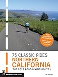
Published 13 Mar. 2014.
458 pages.
View on Amazon
Cycling groups in San Francisco
Both San Francisco and Marin have excellent and very active bicycle coalitions that campaign hard for better and safer cycling conditions. These are the San Francisco Bicycle Coalition and the Marin County Bicycle Coalition.
I’ve noticed a huge difference since I arrived 25 years ago. The network of bike paths and bike lanes in both San Francisco and Marin is growing all the time, thanks to their advocacy.
Rules of the road
A lot of the quieter roads have a bicycle symbol painted on the tarmac to indicate they are recommended bike routes. In general, drivers are extremely courteous and considerate of cyclists here. Obviously, you still get the odd idiot, but thankfully they are very few and far between. And like anywhere, cyclists should always respect the rules of the road and that way everyone is happy!
Note that from 1 January 2022 there is a 15mph enforceable speed limit for bikes crossing the bridge, and anyone exceeding it could face a fine of between $238 and $450. More information here.
You can find California’s bike laws for cyclists here.
Is there anything visitors shouldn’t miss when not cycling?
If you’re coming to the Bay Area with friends or family who are not into the idea of cycling around San Francisco, the hiking here is wonderful, and particularly in Marin. Take a drive up the Marin Headlands to Battery Alexander Parking Area and take the short hike down to South Rodeo Beach. During the week you’ll likely have it to yourself.
There are other small deserted beaches in the Headlands but they’re harder to get to. And any hike on Mt Tam will be breathtaking. Further afield, there’s Point Reyes National Seashore with superb hiking trails and gorgeous beaches.
Exploring San Francisco
As for San Francisco, it truly is one of the world’s most unique urban environments. It’s made up of neighbourhoods, each one with its own character, and is brilliant if you enjoy walking (and don’t mind hills!).
That said, be aware of where you’re going, because some neighbourhoods can quickly become unsavoury from one block to the next. Like any city, it’s always best to check with your hotel or someone with local knowledge before embarking on a particular walk, just to make sure you’re not going to cross into an area that might feel threatening. Some of the downtown areas like the Tenderloin, for example, can be very unnerving.
This is a great guide to San Francisco for visitors.
Walking tours in San Francisco
My favourite neighbourhoods for walking are Pacific Heights, Presidio Heights, Cow Hollow, the Marina and North Beach, but mainly because they are local to where I live (Pacific Heights). The city runs excellent walking tours, which are free although you are expected to tip at the end.
Or you could buy a copy of Stairway Walks in San Francisco by Adah Bakalinsky, which has a large selection of walks in different neighbourhoods, all featuring stairways. It’s a great way to discover the city’s ‘hidden gems’. There’s also the San Francisco City Pass or CityPASS which is a multi-attraction ticket.

Published 22 Sept. 2014.
304 pages.
View on Amazon
Also, be sure to check out Macondray Lane between Leavenworth and Taylor (it was the inspiration for the Barbary Lane of Armistead Maupin’s Tales of the City), and the Land’s End walk from Seacliff to Ocean Beach which offers unparalleled views of the Golden Gate Bridge and Marin Headlands from the city side. Crissy Field is lovely too, if you haven’t already explored it by bike.
 View from Conzelman Road, rising above the fog (route 2 below)
  Homes in the Presidio (route 1 below)
 Baker Beach from Washington Boulevard (route 1 below)
My SF Biking Route Suggestions (continued from above)
These are listed roughly in order of distance from San Francisco, from closest to furthest away. Of the five rides, the Stinson Beach is the hardest. I’d say the Stinson Beach and Headlands rides are the most spectacular!
Please note that the photos are roughly in order along the route, but do not necessarily match the paragraph to which they are adjacent.
Route 1: Cycling in San Francisco: Ocean Run
Overview
One of the best cycle routes to enjoy the glorious San Francisco city landscape, this route takes in views of some of the more interesting landmarks, along with the stunning coastline. There are a few optional extras to extend this route too, or just spend a couple of hours touring the parks.
Detail
My go-to San Francisco city bike ride is what I call my “Ocean Run”. It takes in three beautiful urban parks (the Presidio, Lincoln Park and Golden Gate Park), the very ritzy Sea Cliff neighbourhood (think Beverly Hills) and several miles of Ocean Beach.
The road that goes along Ocean Beach is called Great Highway and is about three miles long. It’s closed to traffic from noon on Fridays until 6am on Mondays. There’s a bike path that runs parallel to the road, but I typically stick to the road because there is a good shoulder. The biggest problem you might encounter is sand drifting into the shoulder at certains points, so be on the lookout for that. If it’s bad, there are lots of places where you can cross over to the bike path.
City scenery
For a city ride, this is unbelievably scenic. So much of it is through parks or along the ocean that it’s easy to forget there’s a bustling city just a few miles away. It’s also relatively flat by San Francisco cycling standards. I’ve taken many of our visitors on that route, some of whom rarely, if ever, ride a bike, and everyone seems to have managed it without too much bad language.
I typically turn around at Sloat Boulevard, near the San Francisco Zoo. There are toilets and water here at the oceanside car park, but just up the road on the corner of Sloat and La Playa is the Java Beach at the Zoo café.
You can also go a bit further south from Ocean Beach to Fort Funston via Skyline Boulevard (busy with traffic, but there’s a shoulder and you’re not on it for long). Fort Funston is a protected area within the Golden Gate National Recreation Area and has fabulous views of the coastline from the lookout point at the end of Fort Funston Road. The biggest drawback is returning north and having to make a U-turn at the Olympic Club across two lanes of busy traffic. There are some trails in the park so you could walk your bike back to where Skyline meets John Muir Drive and use the pedestrian crossing, but to get to that point you’ll be dodging lots of dogs on the trails and will probably need to push your bike through some patches of sand. All perfectly doable, but requires patience!
 Approach to the Golden Gate Bridge from the south east side
 View of Baker Beach from Lincoln Boulevard
 Descent past Cliff House to Ocean Beach
Exploring Golden Gate Park
The return from this ride is through Golden Gate Park, and if you do enough wiggles you can take in all the main sights: Stow Lake, the band concourse, the De Young Museum, the California Academy of Sciences, the Japanese Tea Garden, the magnificent Conservatory of Flowers, the bison meadow, the angling pools, the police horse stables, the historic carousel, rose gardens, various lawns and picnic areas and more.
In fact, you could easily spend a couple of hours just biking in Golden Gate Park. Currently you can ride from the ocean end of the park all the way through to the panhandle on traffic-free roads, and a campaign is being pursued to make this arrangement permanent. With the exception of Crossover Drive, even the roads that carry traffic are reasonably wide, so cycling around
the park is always a pleasure.
Stick to the route
Quick warning: do not take Crossover Drive! It’s the main north-south traffic route through the park and is like a freeway. John F Kennedy Drive crosses under it, but Martin Luther King Jr Drive doesn’t, so make sure you don’t accidentally turn left onto it. I say that because I did it myself when I first arrived and it’s not something I’d wish on anyone.
Coffee
Occasionally I’ll grab an overpriced takeaway coffee at the Stow Lake Boathouse and drink it on one of the benches overlooking the lake. It’s a really peaceful spot mid-week, especially outside school holidays, and because you walk up to the window, you don’t have to worry about locking your bike up. Alternatively, you could call in at Arsicault Bakery at 397 Arguello Blvd (near Clement) which has some of the best croissants you’ll find in the Bay Area and also serves coffee. There are a few tables outside. There’s also a larger cafe next door, on the corner of Clement Street, which is very nice.
 Golden Gate Bridge from Fort Point
 Java Beach Cafe
 Conservatory of flowers, Golden Gate Park
Optional add-ons
There are a couple of “add-ons” to the ocean run which are interesting and worth doing if you want a bigger sampler of the city’s urban sights.
Twin Peaks
First, there’s Twin Peaks. I’d rate this low on the to-do list, mainly because getting there is neither easy nor particularly cycle-friendly, although the southern side of Twin Peaks Boulevard is currently traffic free. But you do get an incredible, almost 360-degree view of the area from the top and it’s a fairly easy climb.
The easiest way to get to Twin Peaks and avoid riding in traffic is to take 7th Avenue from Golden Gate Park, along Laguna Honda Boulevard (where there’s a good bike lane), then walk the bike over a couple of junctions to the southern part of Twin Peaks Boulevard. From there, I go back the way I came, but you can descend on the north side and pick up Parnassus to go back up over Mount Sutro Open Space Reserve.
Aquatic Park and Mission Bay
The more interesting add-on is from Crissy Field along the Marina, through Aquatic Park (the only hill is at Fort Mason, and it’s short and not overly steep), past Fisherman’s Wharf (be careful here because it can be very busy with tourists and is not very bike friendly – better to avoid altogether and take North Point which has a bike lane) to Embarcadero.
While at Aquatic Park, cycle out along the Municipal Pier for great views of Alcatraz. Once on The Embarcadero, the bike path goes along the water, past the famous Ferry Building, underneath the Bay Bridge, around the famous baseball park, over a little iron bridge to Mission Bay and ends up at Crane Cove Park (toilets here).
This is really a fascinating section of the city. Mission Bay is San Francisco’s newest neighbourhood, developed more or less on wasteland over the past 20 years. Right before Crane Cove Park is The Ramp Restaurant, a really cool outdoor dining spot. Very busy at weekends and evenings, but a good spot for lunch during the week.
Note: tram lines run from Fisherman’s Wharf to Mission Bay and the tracks can be very dangerous for cyclists if a wheel gets caught in them. This happened to two of my friends, so take care if you happen to be riding near them.
The Presidio
The Presidio is an exquisitely landscaped 1,500-acre park on a former military post, and it’s always worth extending your bike ride in San Francisco to explore it. It’s a true urban oasis with forested areas, gorgeous historic buildings, a golf course, tennis courts, playgrounds, and scenic lookouts with stunning views of Alcatraz and the Golden Gate Bridge.
It’s also got beaches, a museum, a visitor information centre, a couple of hotels, a log cabin (used for events), restaurants, a Starbucks (of course!), a variety of businesses, including George Lucas’s film company, Lucasfilm, complete with Yoda Fountain, and many other attractions.
It has miles of hiking trails but also lovely smooth quiet roads (some of which are traffic free) that are perfect for cyclists. Mind you, you’re still riding bikes in San Francisco which means…hills! Some are quite steep, but none are very long. Presidio Avenue is gorgeous and lined with eucalyptus trees. It can be busy with traffic at certain times of day, but there’s a good bike lane if you’re going uphill from Crissy Field, and if you’re descending, you’ll outpace the traffic anyway.
Almost parallel with Presidio Avenue, in the forest, is Andy Goldsworthy’s Wood Line sculpture. There are three Andy Goldsworthy sculptures in the Presidio, actually, and they’re all worth checking out, but easier on foot than by bike.
I typically go through the Arguello Gate to Washington Boulevard, which goes past the golf course and out to the ocean. This is a very scenic, traffic-free route through the forest with a great view of the Marin Headlands at Immigrant Point Overlook and views across the Bay to Alcatraz. As you get towards the coast, you’ll catch a glimpse of Baker Beach below, and then, if you carry on as far as Lincoln Boulevard, you’ll see the Golden Gate Bridge.
Letterman Center
Also worth checking out are the gardens and pond in front of the Letterman Center, although you will have to walk your bike here. For historic buildings, the Main Post, Funston Avenue and General Kennedy Avenue are my favourite stretches. Other interesting landmarks in the Presidio are the Ordonez Gun, the military cemetery and the pet cemetery.
Route 2: Cycling Marin Headlands
Overview
From cycling over the Golden Gate Bridge to stunning panoramas of both the landmark and the city behind it from the Headlands once you reach your destination, this is one of the San Francisco bike routes that will live long in the memory.
Detail
The very best views of the city and Golden Gate Bridge are probably from the Marin Headlands, but don’t even think about doing this ride at the weekend (unless you leave at dawn) because it’s bumper-to-bumper traffic. However, on the average weekday, chances are you’ll only be sharing it with a few fellow cyclists, and it’s heavenly.
Cycling the Golden Gate Bridge
First though, you have to get over the Golden Gate Bridge. This is best done on a weekday morning, no matter where you’re going, and ideally before 10am. Up until 3.30pm Monday-Friday, cyclists need to use the east walkway, which has the best views of the city. However, it’s fairly narrow in parts and bikes have to share the path with pedestrians, so the trick is to get there before the tourist hordes.
After 3.30pm and on weekends and public holidays, cyclists have to use the path on the west side of the bridge. No pedestrians are allowed on that side, but it can still be extremely busy with all the other golden gate cyclists, especially at weekends (including cycling clubs in San Francisco that race over the bridge in packs).
 View from the climb up McCullough Road towards Conzelman Road
 Northbound crossing of the Golden Gate Bridge on the west side
 View from Pt Bonita Trail in winter
Golden Gate hazards to bear in mind
Afternoons are extremely windy, especially in summer. The worst parts on the bridge are around the towers, when the wind quickly seems to swirl and change direction and you can easily be caught off guard. I’ve crossed the bridge when the wind was so strong, even the most strapping cyclists had to dismount and walk their bikes around the towers.
As if that’s not bad enough, right now both paths are lined with construction material, making it even narrower in parts. To be honest, I avoid cycling over the bridge whenever possible because coming back to the city it’s either too busy, too windy or usually a combination of both. However, there’s no denying that if you haven’t done it before, it’s thrilling (but make sure you go early).
Climbing to the Marin Headlands
Depending on which side you cross on, getting up to the Headlands can be a bit confusing. If you cross over on the east walkway on a weekday morning, you can turn into Vista Point before taking Alexander Avenue down the hill towards Sausalito. About halfway down, there’s a sharp right turn onto East Road, which takes you down to Cavallo Point.
I love going this way because first you get glorious views of Angel Island, and then when you get to the bottom, you get a great view of the city and an amazing view looking up at the bridge, as opposed to down on it. You then pass underneath the bridge on your way up to the west side car park (toilets here) and Conzelman Road.
If you’re starting at the bottom in Cavallo Point it’s an 800-foot elevation gain, but if you choose to start at the bridge, it’s only 600 feet. (From the east walkway, you’ll either have to go down the steps beneath the bridge and up the other side to the car park, or turn left under the freeway instead of descending Alexander Avenue. As I say, a bit complicated!)
 View from Cavallo Point
 View of the climb from Cavallo Point
- biking san francisco") Descending Conzelman Road
Descending Conzelman Road
Incredible San Francisco views as you climb
The climb up Conzelman Road to Hawk Hill is absolutely spectacular. There’s a very short but quite steep section at the beginning but once you get to the first scenic lookout, the rest is pretty easy. The road is beautifully paved and there is a wide bike lane in both directions.
As you climb up the road, the views just get better and better – this is what San Francisco bike riding is all about. If you happen to cross the bridge in the fog (a near-certainty if you come here in summer), you might be lucky enough to see the towers of the bridge poking through. It’s an awesome sight. When you reach the top, assuming it’s not fogged-in, the panorama is breathtaking. The Golden Gate Bridge is below you and you can see for miles towards the East Bay and the south.
Once you’re at the top of Hawk Hill (toilets here, by the way), check out the views on the other side by going through the tunnels. You’ll lose the view of the city and instead just see a marvellous rugged coastline. You’ll also get to see the road you’re about to take down to Rodeo Beach!
The journey down
That one-way descent is very steep (18% in places) but utterly exhilarating. It hugs the coastline, and you feel like you’re on one of the world’s most scenic helter-skelters. Chances are you will only be able to glance at the view, because it’s steep and fast and you need to keep your wits about you. That said, it has mostly gentle curves (just one is very sharp) and a great surface.
(Note: if you can’t face descending the 18% gradient from Hawk Hill (although admittedly the steepest bit is short), you can go back down to the mini roundabout, which is less than a mile away, and take the gentler descent of McCullough Road, then turn left at the bottom towards Rodeo Beach.)
I always go out towards Point Bonita Lighthouse (no bikes allowed after the car park) and cycle across to Battery Mendell for more coastal views. It’s a short gravel trail but fine for a road bike. It feels very remote and yet the city is just around the corner. It’s also not unusual to see the odd coyote ambling along minding its own business.
Then there’s another nice descent down to the Marin Headlands Visitor Center (toilets and water) and a lovely ride around Rodeo Lagoon, past the Marin Mammal Center and up to the historical Battery Townsley. The road surface isn’t great after the Mammal Center but it’s closed to traffic and is fine for road bikes, plus it’s a gentle climb with stellar views of the coastline and Rodeo Beach.
 Start of descent from Battery Townsley towards Rodeo Beach
 Rodeo Beach viewed from Battery Townsley
 Rodeo Lagoon from Bunker Road
Another exhilarating descent
From Battery Townsley, it’s a fast, twisty descent back down to the black sand beach. Enjoy the magnificent view as you get towards the bottom and the brilliant blue ocean suddenly appears through the trees.
To get back to San Francisco from Rodeo Beach, you can either take Bunker Road and go through the Barry-Baker Tunnel (thankfully downhill in that direction) towards Cavallo Point or take McCullough Road which climbs back up to Conzelman Road, and then you’ll descend back to the bridge. That option works well if you’re crossing back to San Francisco after 3.30pm since you’ll end up on the right side.
Route 3: San Francisco to the Ferries
Overview
This bike ride from San Francisco to Sausalito, Tiburon and Larkspur Landing is exceptionally varied, with a marina packed with luxury yachts, a village of houseboats, some charming coffee shops and restaurants, forests, coves and stunning views throughout. With only a few optional climbs it’s also one of the more gentle road bike routes San Francisco has to offer.
Detail
The third ride I’d recommend is relatively flat. It takes you over the bridge to Sausalito, Tiburon and Larkspur Landing where you have a choice of ferry rides back to the city.
Most tourists on rental bikes end their journey at the ferry after biking to Sausalito from San Francisco, which is a shame because there’s so much to see beyond there. Also, the route becomes relatively quiet after the Sausalito ferry terminal (assuming you’re riding mid-week).
Coffee stops
My favourite place to stop for coffee on a Sausalito bike ride is Taste of Rome. It’s next to a lovely yacht harbour and is very bike-friendly. Another very bike-friendly café, just a couple of hundred yards further down the road on the left, is Equator Coffee. There are a few Equators in Marin – it’s a local chain and very much geared towards cyclists.
If you want to go more upmarket, however, you can make your way along the water, past Sausalito Beach (a hidden gem of a tiny beach with palm trees) to Le Garage.
I always feel a bit like I’m in Saint Tropez when I’m at Le Garage. Many beautiful yachts are moored at this marina and it’s so peaceful, it would be easy to spend the rest of the day there. Le Garage is strictly speaking a restaurant, but if you get there in the morning (it opens at 11.30) you can get a cappuccino and a croissant for restaurant prices. Still, now and again it’s worth the splurge.
To get to Le Garage, immediately after Dunphy Park (a lovely little park, incidentally, with beach volleyball and bocce ball courts, plus toilets and filtered water), look out for a couple of wooden bollards at the entrance to a short path. That will take you behind a brown shingled building and then you’ll turn right down to the beach and, beyond that, Le Garage.
 Sausalito Central Waterfront
 View of the Marin Headlands from the west side of the Golden Gate Bridge
 Le Garage, Schoonmaker Point Marina, Sausalito
The Marina sights
You can actually wiggle your way all along the water, past Liberty Ship Marina (there’s a very short gravel section here through Bayside Boatworks), Clipper Yacht Harbor and Waldo Point Harbor to the start of the Mill Valley-Sausalito Path, or just head back to the main road and take the bike lane to the start of the path
It’s worth meandering around the houseboats before entering the Mill Valley-Sausalito Path. There’s not just a few but an entire village! They vary from the quirky to the downright luxurious. Absolutely fascinating to see, with the docks decorated with plants and flowering shrubs and other idiosyncratic adornments.
The Mill Valley-Sausalito Path at Mike’s Bikes is a two-mile flat route across Bothin Marsh, a well-known local bird sanctuary that is home to more than 400 species of birds. It’s a very pleasant flat ride, albeit a little windy, and brilliant for bird watching. You’ll also get a great view of Mt Tam up ahead. There are toilets and filtered water at the mini roundabout, opposite the skateboard park.
Strawberry Point
I always leave the path at this point and turn right over the wooden bridge towards Seminary Drive and Strawberry Point. You have to pass under the freeway past the beautiful Acqua Hotel, but almost immediately can pick up a path that goes behind the Chevron petrol station, then along a marsh to Seminary Drive a few hundred yards later.
The ride around Strawberry is gorgeous. The road is very quiet and perfect for cycling, and the views are fabulous, as are most of the houses you’ll pass. You can then pick up the Bay Trail at Harbor Cove Way (a short, steep descent) and eventually end up on the bike path at Blackie’s Pasture.
As you cycle along the bike path at Blackie’s Pasture, you’ll get more great views of Mt Tam and the Golden Gate Bridge. I turn right when the bike path crosses over San Rafael Avenue and continue on San Rafael Avenue around Richardson Bay to Belvedere Island. San Rafael Avenue is a flat route to the San Francisco Yacht Club, but if you’ve got the legs for it, you can peel off at Golden Gate Avenue and climb about 0.25 miles up a very steep pitch (average 13%) to Belvedere Avenue to see how the other half lives.
 Houseboats at Richardsons Bay Marina, looking towards Mt Tam
 View over Paradise Cay from Paradise Drive
 Corinthian Island, Belvedere
Alternative option
A gentler version of this loop is to do it clockwise up Beach Road and back down Golden Gate Avenue. The homes here are unreal (worth tens of millions each) and the views are spectacular. In fact, Belvedere Island has some of the most expensive properties in the entire Bay Area.
As you make your way across Belvedere Cove, notice the homes across the water on Corinthian Island. You might even see pelicans feeding in the cove.
Refuelling stop
After going through the quaint Ark Row, you get to downtown Tiburon and the ferry terminal. The most famous eating place here is Sam’s Anchor Café, which is more of a restaurant than a café, but it has a huge deck at the back overlooking the water and you can get dishes like fish and chips.
Alternatively, you can grab a snack at Caffè Acri on the next corner, or wait until you get to Larkspur Landing (the fabulous Rustic Bakery) or, my personal favourite, Emporio Rulli in the pretty little town of Larkspur – both about 10 miles from Tiburon along the aptly named Paradise Drive.
The peace of Paradise Drive
This is when the ride gets even more scenic. There’s a short, relatively easy climb up from Tiburon and then the road is gently undulating as it twists its way along the hillside, above the bay, offering yet more spectacular views.
There is very little traffic on this road, which is probably why it’s one of the more popular bike rides in San Francisco’s surrounding area. It’s actually a good ride to do on a Sunday, because traffic is light even at weekends. There is a lovely park along the way called Paradise Beach County Park that overlooks Paradise Cove. It’s a steep descent down, but short enough to push your bike back up if you need to. Off season or during the week, you’re more than likely to have it to yourself. It’s a lovely spot for a picnic.
Paradise Drive eventually turns into San Clemente Drive where a very nice bike path begins. Follow that to the end, with San Quentin prison in the distance to your right, and then you have a choice, either to carry straight on to Larkspur Landing and ferry back to the city (after a coffee and pastry at the Rustic Bakery, of course), or turn left under the freeway to the lovely little town of Larkspur (not to be confused with Larkspur Landing, which is where the ferry terminal is).
 View of South Larkspur
 Tiburon Linear Park Bike Trail
 South Larkspur again!
Ferry terminal or Larkspur
To go to Larkspur Landing, just keep going straight, take the bike path over the water and then drop down to the bike path that goes along the side of the main road towards the ferry and/or Larkspur Landing shopping centre.
To head instead to Larkspur (and Emporio Rulli!), follow the path under the freeway, cross over at the lights and continue straight onto the Larkspur Path towards Mt Tam. Eventually you turn right and come off the path near Cane Street.
If you then want to get the ferry back from Larkspur Landing, it’s a nice ride over Bon Air Road Bridge, up and over San Eliseo Drive to the bike path at Corte Madera Creek.
Biking back from Larkspur
Otherwise, to get back to the city from Larkspur, go back along the bike path to Redwood Avenue, turn right half a block to the traffic lights, then take Corte Madera Avenue up the hill to Camino Alto. It’s a lovely, fairly gentle climb through forest with a great view towards the city from the top. Then it’s a zippy descent back down to the Mill Valley-Sausalito Path and on through Sausalito to the climb back up Alexander Avenue to the bridge.
Route 4: Stinson Beach, Bolinas and Mt Tam
Overview
Explore some of the most breathtaking scenery that Northern California bike rides can provide with this incredible route. It’s got some good climbs to challenge you but in exchange you’ll get some amazing views through rich, diverse scenery, with some great spots to stop and soak it all in.
Detail
Of all the rides out of San Francisco, this is by far the most beautiful and rewarding. If I could only do one more ride from the city, it would be this one. It involves a lot of climbing, but is so consistently spectacular that it should be on everyone’s bucket list.
Where to start (and when)
Most of the ride after Mill Valley is within a state or national park. I usually start this cycle ride in Marin but have done it from the city. There are any number of places to start in Marin, but for simplicity, I’ll suggest Sausalito, because then you can take in the bike path along Bothin Marsh.
Again, this is not a ride I would do at the weekend because there’s too much traffic. But on a weekday, and especially off-season (i.e. outside school holidays), the traffic goes from manageable to non-existent. Bill Oetinger describes it as “a landscape of pristine wilderness and spectacular natural beauty” from start to finish and I couldn’t put it better myself!
 Descent to Muir Beach
 Highway 1 looking south towards Muir Beach
 Stinson Beach view across the sea
From Mill Valley into the forest
The town of Mill Valley is really pretty, and if you need caffeine before you start climbing, check out Equator Coffees or The Depot Plaza. Then head to Old Mill Park (toilets and water here) and go through the forest on Cascade Drive to Marion Avenue, which is virtually traffic-free.
This climb is really beautiful, all wooded with lovely houses and cottages. Then when you get to Edgewood Road, turn right and continue climbing. The name changes to Sequoia Valley Road and leads up to what’s known as Four Corners – the junction of Panoramic Highway and Muir Woods Road.
Here you have a choice. You can either go straight on down the twisty Muir Woods Road to the Muir Woods National Monument (not a monument in the traditional sense of the word, but a historic redwood forest) and then Frank Valley Road to Highway 1, or you can turn left on Panoramic and cycle about 0.8 miles to Highway 1, where you’ll make a very sharp right-hand turn down to Muir Beach.
Heading to Muir Beach
I prefer the second option because the descent on Highway 1 is exhilarating, especially as the ocean looms closer and closer. When you get to the bottom, you’ll see on the left the famous Pelican Inn, which looks like it’s been lifted straight out of the English west country. Turn left there and go to Muir Beach.
You can cross over a wooden boardwalk and walk your bike up the trail to a bench that overlooks the water. It’s a beautiful spot and a good place for a snack before returning to Highway 1 and starting the next climb. This is a one-mile, fairly steep ascent up to the bluffs above the ocean.
If you have time, call in at the Muir Beach Overlook. Just be careful turning left into the entrance. The views from here are spectacular.
 Hwy 1 between Stinson Beach and Bolinas along the Bolinas Lagoon
 Bolinas Bay from Ocean Parkway
 Olema Bolinas Road along the Bolinas Lagoon
Onwards to Stinson Beach
After that, it’s back onto Highway 1 for the ride to Stinson Beach. I have done this ride dozens of times (probably well over a hundred times) and it never fails to take my breath away, even when it’s shrouded in fog.
Again, I just have to quote Bill Oetinger here, because his description is so spot on. “This begins a fabulous 5-mile dance along the hillside, always gently up or down, always on silky-smooth pavement, and always with the blue Pacific on display, far below. You might think this is about as beautiful as a bike ride can be, but all I can say is: you ain’t seen nothin’ yet!”. And when you get your first glimpse of Stinson Beach below, in the distance, I guarantee you’ll gasp out loud.
Coffee stop
I always stop for coffee and a snack at The Parkside Café kiosk, which serves great cappuccino, delicious cakes and pastries and excellent pizza. You can eat in the park opposite, or, if you can carry it, take your purchase to the beach. The entrance is to the right of the café – it’s small, but obvious. There’s a boardwalk at the beach with some benches at the end. Stinson Beach is my favourite spot to ride to. I love it there.
Breathtaking Bolinas loop
Next comes a glorious ride along Bolinas Lagoon. Look out for an incredible variety of sea birds, including herons, egrets and pelicans, plus seals sunbathing on a sandbank – they’re always there.
I also highly recommend doing the seven-mile loop around Bolinas, which is not signposted (deliberately – the locals removed the sign and it’s never been put back) but it’s the first left-hand turn you come to after the lagoon.
Bolinas is a historic town that is so singularly quaint and quirky, that you’ll be really glad you made the detour. You can go straight to the town, but I like to turn right at Mesa Road and climb the hill to Overlook Drive. It’s a pretty stiff hill (max 15%) but short. Take the first left onto Overlook Drive and cycle to the end of the road, which stops 200 feet above the ocean. I guarantee it will put a smile on your face. There’s a lovely descent back to the town with gorgeous vistas.
 Early part of the climb up Bofax Road looking down at Bolinas Lagoon
 Top of Bofax Road and start of the Seven Sisters
 One of the seven sisters on Ridgecrest in early summer
Fairfax-Bolinas Road climb
If you skip Bolinas, just take the first turning on the right immediately after the lagoon, over the cattle grid and start the ascent up Fairfax-Bolinas Road (or BoFax Road as it’s known locally). This is one of my favourite climbs in Marin. It’s a long climb – four miles before the first noticeable respite – but absolutely beautiful and almost always traffic-free.
If you’re doing this in winter or spring after the rains, the series of waterfalls cascading down the hillside after about Mile 2 will literally stop you in your tracks. Eventually you’ll end up on Ridgecrest, seemingly deep in a forest of redwoods.
A left-hand turn at this point will give you a twisty two-mile descent to Alpine Lake and then an undulating climb back up towards Fairfax – a sensational route and definitely worth considering for another ride (get all the details here).
But the ride I’m focusing on involves bearing right to tackle what is known locally as the “seven sisters” – seven short hills of varying degrees of steepness. At least they’re short.
Ridgecrest and Rock Spring
Ridgecrest really is one of the crown jewels of Marin cycling – you’re high above the ocean, the views are absolutely spectacular, and the undulating road (almost always traffic-free on a weekday) with its gentle curves is a joy to ride. In winter and spring, the hills are green and in April and May are covered in orange, white and purple wildflowers. I can honestly say that Ridgecrest on a sunny day in the spring, when the wildflowers are in full bloom, is the most breathtaking stretch of road I’ve ever cycled.
Once you get to Rock Spring, there’s the option of climbing up to East Peak, the highest point of Mt Tam and definitely worth it if you’ve got the legs, or saving it to do as a standalone ride on another day.
Rock Spring is where the descent back to Mill Valley begins. It’s unbelievably scenic, especially at the start of the descent when you get spectacular views of San Francisco and the ocean. After just over a mile, you reach Pantoll Ranger Station (toilets and water!), from where you will turn left and wend your way back down through the forest. You’re likely to encounter some traffic after Pantoll, but if you’re a fast descender, you’ll probably beat the cars down the hill. And if you’re a bit slower, like me, there are several “pullouts” where you can allow cars to overtake safely.
 Spring flowers on Ridgecrest looking east
2- biking san francisco") View from the summit of Mt Tam (East Peak)
View from the summit of Mt Tam (East Peak) Road between Rock Spring and Pantoll in winter
Options from Four Corners
You’ll eventually come to Four Corners again, and you could turn right to take Highway 1 back to Tam Junction and Sausalito, but that carries more traffic, so I always turn left to go back down Sequoia Valley Road and then turn right at the third stop sign onto Jane Street.
You could keep going straight, but the gradient is very steep and you have to hit the brakes really hard to pull up at the Stop sign at the bottom. Jane Street, on the other hand, is a lovely smooth, quiet, gentle descent past pretty houses with nice landscaping and brings you out at the same point.
The famous fork
Don’t miss the fork in the road where Jane meets Montford Avenue where there is literally a large sculpture of a fork! Always fun to see and the “fork” is often decorated to suit the season, so with a witch’s hat at Halloween, for example, or a reindeer’s nose and cloth antlers at Christmas. I’ve even seen it wrapped in rope to mimic spaghetti.
From the bottom, I go straight over Miller to La Goma Street and back to the Sausalito bike path, but you could turn left up Miller if you want to call in at one of the cafes in Mill Valley (the Lumber Yard, Equator Coffee or The Depot, which I mentioned earlier), or turn right and take the bike lane until you see the entrance to the Sausalito bike path. (I prefer to enter the bike path from Sycamore, though.)
Mill Valley loop
https://ridewithgps.com/routes/38144581 – note that this map starts at Mike’s Bikes in Sausalito but you can pick it up in downtown Mill Valley at Equator Coffee.
As a side note on this ride, there’s a gorgeous loop around Mill Valley if you follow Cascade Drive all the way to the end, through the redwoods and along the creek, to where it turns into Lovell Avenue, which then takes you back to downtown Mill Valley. It’s about three miles and best done clockwise.
 Road between Rock Spring and Pantoll in summer
- biking san francisco") Stinson Beach panorama from Ridgecrest
Stinson Beach panorama from Ridgecrest Descent to Muir Beach from Four Corners via Muir Woods
Route 5: Cycling West Marin (Point Reyes Station and Marshall)
Overview
From the views of Tomales Bay to the glorious redwood forest of Samuel P Taylor Park, this route has some glorious scenery to enjoy, including quieter roads where you can just absorb the beautiful nature of California. There’s a few challenging climbs, but plenty of great rest stops too for refuelling.
Detail
One of my other top destinations is Point Reyes Station. There are a number of combinations of very scenic bike routes to get to this lovely little town, which has at least four great options for takeaway coffee and pastries or snacks – Toby’s, the Bovine Bakery, Brickmaiden Breads and the Cowgirl Creamery.
Where to start
For Point Reyes rides, I typically start in the overflow car park at Corte Madera, or opposite the community centre at Marinwood Park, just off Lucas Valley Road. If you start in Corte Madera, you can cycle through the pretty towns of Ross, San Anselmo and Fairfax to Sir Francis Drake Boulevard which ends up in Point Reyes.
 Big Rock in summer
 Old St Mary’s Church, Nicasio in winter
 Honesty coffee stand along Lucas Valley Road
The scenic – but hilly – route
But the more spectacular ride – and the one with the most climbing – is to go the long way around via Marshall. From Marinwood Park, you cycle along Lucas Valley Road (there’s a designated bike lane for the first four miles) up to Big Rock, which is a moderate climb of about ¾ mile.
From there, you have a nice curvy descent down through the redwood forest (note George Lucas’s “Skywalker Ranch” at number 5858) and eventually get to open pasture and horse farms. Turn right at the T-junction to Nicasio, a tiny hamlet with a historic little church and a general store that sells the basics including drip coffee and water. There are toilets here but no water fountain.
From Nicasio, you have a nice stretch of road with a wide shoulder that takes you along the Nicasio Reservoir to the junction with Point Reyes-Petaluma Road, where you’ll turn right to go to Marshall. If you turn left here, you’ll still end up in Point Reyes but you’ll have missed the best bit, including those lovely big climbs!
The journey to Marshall
This can be a busy road, but there’s only a short section where you’ll be yearning to get off it onto the beautiful and quiet Hicks Valley Road. Otherwise, the first bit is a moderate climb on a decent shoulder. Don’t miss the good view of “Elephant Mountain” behind you. Then there’s a short, fast descent, and about three miles along the valley floor before the left turn onto Hicks Valley Road.
Before you get there though, you’ll pass the Marin French Cheese Company on the left, just before the fire station. This is the last place for toilets and refreshments until you get to Marshall. It has a lovely picnic area overlooking a duck pond.
The ride along Hicks Valley Road and then Marshall Petaluma Road is your archetypal “backroads” cycling. It’s simply gorgeous – very tranquil and bucolic, and in spring the road is lined with bright orange Californian poppies and other wildflowers.
You have about 10 miles to relax on gently undulating road before you’ll be standing up on the pedals to begin the two-mile climb up over the hill to Marshall. The first half mile is the steepest (12% max), then it eases out. It can be very windy, especially in summer, so be prepared for a bit of a slog. Still, it’s worth it for the views from the top over Tomales Bay, which are spectacular.
 Hicks Valley Road
 One of the picturesque barns on Marshall Petaluma Road
 View from Marshall summit over Tomales Bay
Descent to Highway 1 and Point Reyes Station
Then it’s a fabulous descent to Highway 1. This next part of the ride is every bit as exhilarating as the descent you’ve just done, but for different reasons. It’s gently undulating all the way to Point Reyes Station (apart from one short stiff hill) and much of it skirts the water, passing oyster farms and waterside oyster bars, my favourite being the Marshall General Store. Check opening times as it’s not open every day. They do a good clam chowder and you can sit at one of the tables overlooking the water, gazing out at the little boats bobbing up and down and the odd seal popping its nose out of the water.
Again, it’s worth remembering only to do this ride on a weekday because Highway 1 can be very busy on weekends.
Options after Point Reyes
After a stop in Point Reyes Station (toilets and water on Mesa Road and Toby Street), you can head back towards Nicasio via Point Reyes-Petaluma Road, which will repeat part of the road you started on. Or, for a slightly longer ride with new scenery, I would suggest heading out of Point Reyes Station on Highway 1 and turning immediately right after the iron bridge onto Sir Francis Drake Boulevard, then first left on Bear Valley Road.
This is a lovely quiet road that goes past the Bear Valley Visitors Centre and brings you out on Highway 1 at Olema. There is a very nice general store at the junction of Hwy 1 and Sir Francis Drake Boulevard called Due West that serves espresso and pastries and has attractive outdoor seating, plus plenty of bike parking and portable toilets. Turn left at the stop sign and climb up Sir Francis Drake Boulevard (don’t worry – it’s reasonably gentle and not too long) and down towards Lagunitas Creek.
 Descent from Marshall summit towards Tomales Bay
 Outdoor seating at Marshall General Store
 Highway 1 heading towards Point Reyes Station from Marshall
Seeing Samuel P Taylor Park
Just before the bridge over the creek, you’ll see a sign on the right that says “Bike Path”. This is the Cross Marin Trail that goes through Samuel P Taylor Park and is absolutely exquisite. It’s well paved and runs above the creek, through some grassland and then through the redwood forest, which is studded with ferns and just breathtaking.
After 3.9 miles you come out at the campground where there are picnic benches, toilets and water. I have been here multiple times during the week and had the place all to myself. It’s absolutely magical.
You can sit amongst giant redwood trees that are more than a thousand years old and hear nothing but birdsong and the babble of the nearby creek. Most visitors to the Bay Area flock to Muir Woods, which has millions of visitors every year, but in my view you get the same spiritual experience in SPT Park, because as I say, off season and outside peak times, chances are the only other person you’ll see is the local ranger.
A trail to avoid on a road bike
The trail actually continues above the campground and comes out further up the road on Sir Francis Drake Boulevard, but it’s not paved and although it’s doable on a road bike in dry weather, it’s not the greatest. I’ve done it twice, and after the second time I wondered why I didn’t learn the first time.
But it’s a great trail for families if you have the right bikes because it’s flat. Anyway, I leave the park by the main entrance and get straight back on Sir Francis Drake Boulevard, which is smooth and beautiful but does carry traffic. That said, it’s quite wide and once you get to Lagunitas, there’s a shoulder.
 Highway 1 just after Marshall
 Public garden and picnic spot in Point Reyes Station
 Cross Marin Trail bike path in Samuel P Taylor Park
Coffee
Not far from Lagunitas is Forest Knolls and a fabulous coffee spot called Pump Espresso Bar. Lovely people, great coffee and fantastic selection of muffins, scones, pizza and other delectable snacks. It’s very close to SPT Park, so you probably won’t need water, but if you do, they will let you fill up your water bottle from their water dispenser (and they also have toilet facilities).
The return to Lucas Valley Road
To get back to Lucas Valley Road, you have to climb up Nicasio Valley Road. It’s an easy climb but there can be a lot of traffic towards the end of the day. However, it’s fairly short and the road itself is very picturesque, dropping down through forest, past horse farms. And when you get to the junction with Lucas Valley Road, there’s only one climb left on the whole ride. That’s the one to Big Rock, which is gentler in that direction than the way you came.
Please support Epic Road Rides
A huge amount of time and effort goes into the article you’ve just read, all with the aim of helping you!
If you found what you’ve read useful, I’d really appreciate it if you dropped something in the tip jar here.
It’s a way you can say thank you and help us carry on creating top quality content with no annoying ads and no pay wall.
Looking for an organised cycling trip?
If you want someone to help you plan and book your cycling holiday, fill out this form. We aren’t a tour operator/agent but we work with lots of people who are and will do our best to put you in touch with someone that can help (within 24 hours where possible)!Sarah Llewellyn is a cyclist from the UK who has lived in San Francisco for many years. She says "When my husband and I moved from London to San Francisco in 1997, we told our families we’d be gone between three and five years. But more than 25 years later, we're still here! The Bay Area has so much natural beauty and so much to offer in terms of outdoor activities that we have never stopped reminding ourselves how lucky we are to live here.
I’m also fortunate to work as a freelance translator (French into English) so have lots of flexibility with my work schedule and am the first to admit that I typically fit work around cycling, rather than the other way around.
I nearly always ride during the week because weekends tend to be very busy. I typically choose routes with very little traffic but not so remote that if, heaven forbid, something were to happen, there wouldn’t be someone passing by to help. Actually, solo riding among women is very common here."
First Published: 13 January 2022
This article includes details of products and/or services that we have used ourselves or which we would consider using. Some are paid features or include affiliate links or referral codes which we may earn commission from. As an Amazon Associate we earn from qualifying purchases. Please read our disclosure policy for further information.
The contents of this website are provided for general information purposes only. It is not intended to amount to advice and you should not rely on it. You should carry out your own due diligence and risk assessments and take professional advice. Views expressed by interviewees or other users of this website do not necessarily represent our views. We make no representations, warranties or guarantees, whether express or implied, that the content on our website is accurate, complete or up to date. If you use any information or content on this website, download from, or otherwise obtain content or services through our website, it is entirely at your own discretion and risk. Epic Road Rides Ltd disclaims all liability and responsibility arising from any reliance placed on the information and content on this website. Find out more here.